|
|
|||||||||||||||||
| Point ID: 6876 | Downloads | Plots | Site Data | Code: 10502 |
|
|
|||||||||||||||||
| Download | |
|---|---|
| Site Descriptor Information | Site Time Series Data |
| Link to all available data | |
| View: | Time Series | All |
| Units: | m3/s |
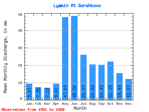
| Statistic | Jan | Feb | Mar | Apr | May | Jun | Jul | Aug | Sep | Oct | Nov | Dec | Annual |
|---|---|---|---|---|---|---|---|---|---|---|---|---|---|
| Mean | 9.37 | 7.41 | 7.13 | 9.40 | 47.69 | 48.56 | 26.06 | 20.60 | 20.43 | 22.15 | 15.43 | 12.07 | 246.86 |
| Standard Deviation | 3.07 | 2.30 | 1.71 | 4.02 | 17.08 | 17.88 | 11.21 | 15.13 | 9.58 | 11.60 | 6.15 | 5.66 | 67.70 |
| Min | 6.00 | 4.73 | 4.69 | 4.62 | 15.06 | 19.48 | 12.97 | 8.85 | 8.93 | 9.64 | 7.61 | 6.15 | 164.13 |
| Max | 23.64 | 16.28 | 11.82 | 22.27 | 82.43 | 78.77 | 69.46 | 84.31 | 51.84 | 61.93 | 36.65 | 38.70 | 474.49 |
| Coefficient of Variation | 0.33 | 0.31 | 0.24 | 0.43 | 0.36 | 0.37 | 0.43 | 0.73 | 0.47 | 0.52 | 0.40 | 0.47 | 0.27 |
 Return to R-Arctic Net Home Page