|
|
|||||||||||||||||
| Point ID: 6876 | Downloads | Plots | Site Data | Code: 10502 |
|
|
|||||||||||||||||
| Download | |
|---|---|
| Site Descriptor Information | Site Time Series Data |
| Link to all available data | |
| View: | Time Series | All |
| Units: | mm |
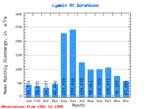
| Statistic | Jan | Feb | Mar | Apr | May | Jun | Jul | Aug | Sep | Oct | Nov | Dec | Annual |
|---|---|---|---|---|---|---|---|---|---|---|---|---|---|
| Mean | 44.77 | 38.89 | 34.10 | 46.45 | 227.92 | 239.82 | 124.58 | 98.46 | 100.91 | 105.87 | 76.20 | 57.69 | 100.12 |
| Standard Deviation | 14.69 | 12.05 | 8.19 | 19.87 | 81.62 | 88.27 | 53.59 | 72.33 | 47.30 | 55.44 | 30.39 | 27.07 | 27.46 |
| Min | 28.70 | 24.80 | 22.40 | 22.80 | 72.00 | 96.20 | 62.00 | 42.30 | 44.10 | 46.10 | 37.60 | 29.40 | 66.57 |
| Max | 113.00 | 85.40 | 56.50 | 110.00 | 394.00 | 389.00 | 332.00 | 403.00 | 256.00 | 296.00 | 181.00 | 185.00 | 192.44 |
| Coefficient of Variation | 0.33 | 0.31 | 0.24 | 0.43 | 0.36 | 0.37 | 0.43 | 0.73 | 0.47 | 0.52 | 0.40 | 0.47 | 0.27 |
 Return to R-Arctic Net Home Page