|
|
|||||||||||||||||
| Point ID: 6875 | Downloads | Plots | Site Data | Code: 10501 |
|
|
|||||||||||||||||
| Download | |
|---|---|
| Site Descriptor Information | Site Time Series Data |
| Link to all available data | |
| View: | Time Series | All |
| Units: | m3/s |
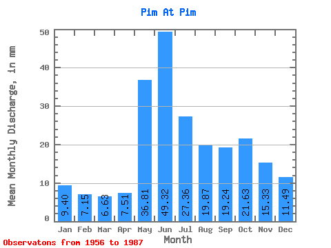
| Statistic | Jan | Feb | Mar | Apr | May | Jun | Jul | Aug | Sep | Oct | Nov | Dec | Annual |
|---|---|---|---|---|---|---|---|---|---|---|---|---|---|
| Mean | 9.40 | 7.21 | 6.63 | 7.51 | 36.81 | 49.32 | 27.35 | 19.87 | 19.24 | 21.63 | 15.33 | 11.49 | 228.30 |
| Standard Deviation | 3.59 | 2.56 | 1.66 | 2.60 | 16.75 | 16.19 | 9.59 | 8.39 | 7.10 | 9.00 | 6.28 | 4.88 | 55.29 |
| Min | 4.24 | 4.09 | 4.40 | 4.39 | 11.21 | 19.88 | 14.55 | 10.28 | 8.11 | 8.35 | 7.42 | 4.61 | 149.33 |
| Max | 20.72 | 16.32 | 10.76 | 14.30 | 79.43 | 85.67 | 53.11 | 47.89 | 37.34 | 46.07 | 37.78 | 27.91 | 400.92 |
| Coefficient of Variation | 0.38 | 0.35 | 0.25 | 0.35 | 0.46 | 0.33 | 0.35 | 0.42 | 0.37 | 0.42 | 0.41 | 0.42 | 0.24 |
 Return to R-Arctic Net Home Page