|
|
|||||||||||||||||
| Point ID: 6875 | Downloads | Plots | Site Data | Code: 10501 |
|
|
|||||||||||||||||
| Download | |
|---|---|
| Site Descriptor Information | Site Time Series Data |
| Link to all available data | |
| View: | Time Series | All |
| Units: | mm |
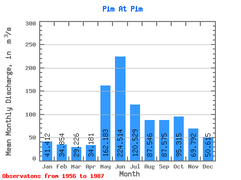
| Statistic | Jan | Feb | Mar | Apr | May | Jun | Jul | Aug | Sep | Oct | Nov | Dec | Annual |
|---|---|---|---|---|---|---|---|---|---|---|---|---|---|
| Mean | 41.41 | 34.85 | 29.23 | 34.18 | 162.18 | 224.51 | 120.53 | 87.55 | 87.58 | 95.31 | 69.79 | 50.62 | 85.36 |
| Standard Deviation | 15.84 | 12.36 | 7.31 | 11.83 | 73.81 | 73.71 | 42.25 | 36.99 | 32.31 | 39.64 | 28.60 | 21.52 | 20.67 |
| Min | 18.70 | 19.80 | 19.40 | 20.00 | 49.40 | 90.50 | 64.10 | 45.30 | 36.90 | 36.80 | 33.80 | 20.30 | 55.83 |
| Max | 91.30 | 78.90 | 47.40 | 65.10 | 350.00 | 390.00 | 234.00 | 211.00 | 170.00 | 203.00 | 172.00 | 123.00 | 149.90 |
| Coefficient of Variation | 0.38 | 0.35 | 0.25 | 0.35 | 0.46 | 0.33 | 0.35 | 0.42 | 0.37 | 0.42 | 0.41 | 0.42 | 0.24 |
 Return to R-Arctic Net Home Page