|
|
|||||||||||||||||
| Point ID: 6869 | Downloads | Plots | Site Data | Code: 10495 |
|
|
|||||||||||||||||
| Download | |
|---|---|
| Site Descriptor Information | Site Time Series Data |
| Link to all available data | |
| View: | Time Series | All |
| Units: | m3/s |
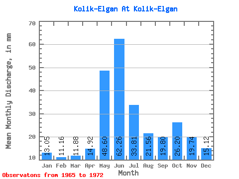
| Statistic | Jan | Feb | Mar | Apr | May | Jun | Jul | Aug | Sep | Oct | Nov | Dec | Annual |
|---|---|---|---|---|---|---|---|---|---|---|---|---|---|
| Mean | 13.05 | 11.26 | 11.88 | 14.92 | 48.59 | 62.26 | 33.80 | 21.56 | 19.80 | 26.19 | 19.74 | 15.11 | 281.52 |
| Standard Deviation | 1.39 | 1.20 | 1.80 | 3.06 | 18.66 | 16.49 | 8.53 | 2.73 | 2.30 | 10.54 | 5.71 | 2.42 | 14.88 |
| Min | 10.86 | 9.63 | 8.88 | 12.68 | 25.61 | 32.31 | 22.38 | 17.83 | 17.29 | 16.66 | 13.46 | 11.12 | 271.68 |
| Max | 14.38 | 12.57 | 13.54 | 19.21 | 71.17 | 78.47 | 46.22 | 24.98 | 22.72 | 46.22 | 28.51 | 17.35 | 298.63 |
| Coefficient of Variation | 0.11 | 0.11 | 0.15 | 0.20 | 0.38 | 0.27 | 0.25 | 0.13 | 0.12 | 0.40 | 0.29 | 0.16 | 0.05 |
 Return to R-Arctic Net Home Page