|
|
|||||||||||||||||
| Point ID: 6869 | Downloads | Plots | Site Data | Code: 10495 |
|
|
|||||||||||||||||
| Download | |
|---|---|
| Site Descriptor Information | Site Time Series Data |
| Link to all available data | |
| View: | Time Series | All |
| Units: | mm |
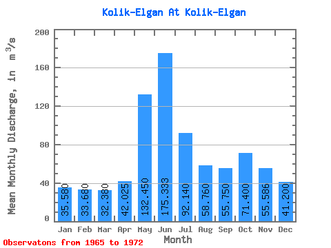
| Statistic | Jan | Feb | Mar | Apr | May | Jun | Jul | Aug | Sep | Oct | Nov | Dec | Annual |
|---|---|---|---|---|---|---|---|---|---|---|---|---|---|
| Mean | 35.58 | 33.68 | 32.38 | 42.02 | 132.45 | 175.33 | 92.14 | 58.76 | 55.75 | 71.40 | 55.59 | 41.20 | 65.12 |
| Standard Deviation | 3.80 | 3.58 | 4.92 | 8.61 | 50.87 | 46.43 | 23.24 | 7.44 | 6.48 | 28.73 | 16.09 | 6.61 | 3.44 |
| Min | 29.60 | 28.80 | 24.20 | 35.70 | 69.80 | 91.00 | 61.00 | 48.60 | 48.70 | 45.40 | 37.90 | 30.30 | 62.84 |
| Max | 39.20 | 37.60 | 36.90 | 54.10 | 194.00 | 221.00 | 126.00 | 68.10 | 64.00 | 126.00 | 80.30 | 47.30 | 69.08 |
| Coefficient of Variation | 0.11 | 0.11 | 0.15 | 0.20 | 0.38 | 0.27 | 0.25 | 0.13 | 0.12 | 0.40 | 0.29 | 0.16 | 0.05 |
 Return to R-Arctic Net Home Page