|
|
|||||||||||||||||
| Point ID: 6865 | Downloads | Plots | Site Data | Code: 10488 |
|
|
|||||||||||||||||
| Download | |
|---|---|
| Site Descriptor Information | Site Time Series Data |
| Link to all available data | |
| View: | Time Series | All |
| Units: | m3/s |
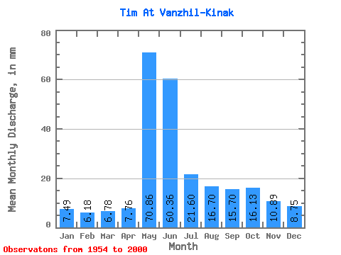
| Statistic | Jan | Feb | Mar | Apr | May | Jun | Jul | Aug | Sep | Oct | Nov | Dec | Annual |
|---|---|---|---|---|---|---|---|---|---|---|---|---|---|
| Mean | 7.49 | 6.23 | 6.78 | 7.76 | 70.85 | 60.37 | 21.59 | 16.70 | 15.70 | 16.12 | 10.89 | 8.75 | 250.65 |
| Standard Deviation | 1.57 | 1.18 | 1.33 | 2.08 | 22.11 | 29.74 | 9.54 | 7.71 | 6.32 | 6.44 | 3.13 | 2.24 | 49.61 |
| Min | 4.72 | 3.75 | 3.82 | 4.16 | 11.67 | 21.02 | 11.90 | 9.20 | 6.72 | 8.75 | 5.26 | 4.53 | 159.91 |
| Max | 12.41 | 9.30 | 9.89 | 13.40 | 119.85 | 154.24 | 66.82 | 45.87 | 34.39 | 29.96 | 17.58 | 15.56 | 362.86 |
| Coefficient of Variation | 0.21 | 0.19 | 0.20 | 0.27 | 0.31 | 0.49 | 0.44 | 0.46 | 0.40 | 0.40 | 0.29 | 0.26 | 0.20 |
 Return to R-Arctic Net Home Page