|
|
|||||||||||||||||
| Point ID: 6865 | Downloads | Plots | Site Data | Code: 10488 |
|
|
|||||||||||||||||
| Download | |
|---|---|
| Site Descriptor Information | Site Time Series Data |
| Link to all available data | |
| View: | Time Series | All |
| Units: | mm |
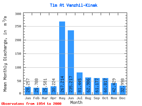
| Statistic | Jan | Feb | Mar | Apr | May | Jun | Jul | Aug | Sep | Oct | Nov | Dec | Annual |
|---|---|---|---|---|---|---|---|---|---|---|---|---|---|
| Mean | 28.26 | 25.79 | 25.58 | 30.22 | 267.21 | 235.22 | 81.44 | 62.99 | 61.18 | 60.82 | 42.43 | 33.00 | 80.21 |
| Standard Deviation | 5.93 | 4.86 | 5.04 | 8.10 | 83.37 | 115.89 | 35.98 | 29.07 | 24.61 | 24.27 | 12.20 | 8.45 | 15.88 |
| Min | 17.80 | 15.50 | 14.40 | 16.20 | 44.00 | 81.90 | 44.90 | 34.70 | 26.20 | 33.00 | 20.50 | 17.10 | 51.17 |
| Max | 46.80 | 38.50 | 37.30 | 52.20 | 452.00 | 601.00 | 252.00 | 173.00 | 134.00 | 113.00 | 68.50 | 58.70 | 116.12 |
| Coefficient of Variation | 0.21 | 0.19 | 0.20 | 0.27 | 0.31 | 0.49 | 0.44 | 0.46 | 0.40 | 0.40 | 0.29 | 0.26 | 0.20 |
 Return to R-Arctic Net Home Page