|
|
|||||||||||||||||
| Point ID: 6860 | Downloads | Plots | Site Data | Code: 10478 |
|
|
|||||||||||||||||
| Download | |
|---|---|
| Site Descriptor Information | Site Time Series Data |
| Link to all available data | |
| View: | Time Series | All |
| Units: | m3/s |
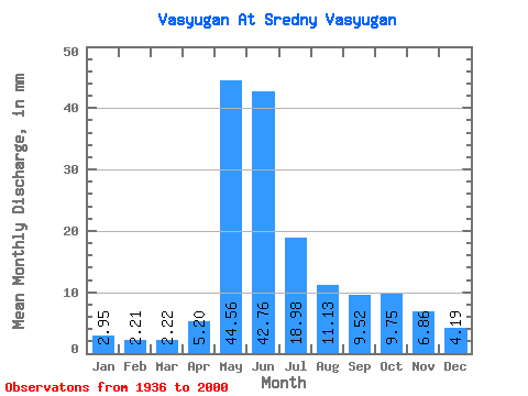
| Statistic | Jan | Feb | Mar | Apr | May | Jun | Jul | Aug | Sep | Oct | Nov | Dec | Annual |
|---|---|---|---|---|---|---|---|---|---|---|---|---|---|
| Mean | 2.95 | 2.23 | 2.22 | 5.20 | 44.55 | 42.76 | 18.98 | 11.12 | 9.53 | 9.75 | 6.86 | 4.19 | 160.00 |
| Standard Deviation | 0.89 | 0.53 | 0.46 | 3.45 | 10.99 | 16.94 | 12.84 | 8.30 | 6.45 | 5.84 | 3.27 | 1.64 | 44.59 |
| Min | 1.45 | 1.07 | 0.90 | 1.03 | 16.98 | 7.95 | 3.79 | 2.53 | 3.08 | 3.08 | 2.44 | 1.60 | 63.63 |
| Max | 5.84 | 3.89 | 3.08 | 14.96 | 62.85 | 70.56 | 54.41 | 41.90 | 25.68 | 25.26 | 13.98 | 8.13 | 286.26 |
| Coefficient of Variation | 0.30 | 0.24 | 0.21 | 0.66 | 0.25 | 0.40 | 0.68 | 0.75 | 0.68 | 0.60 | 0.48 | 0.39 | 0.28 |
 Return to R-Arctic Net Home Page