|
|
|||||||||||||||||
| Point ID: 6860 | Downloads | Plots | Site Data | Code: 10478 |
|
|
|||||||||||||||||
| Download | |
|---|---|
| Site Descriptor Information | Site Time Series Data |
| Link to all available data | |
| View: | Time Series | All |
| Units: | mm |
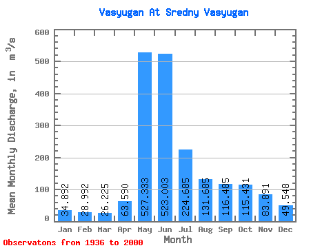
| Statistic | Jan | Feb | Mar | Apr | May | Jun | Jul | Aug | Sep | Oct | Nov | Dec | Annual |
|---|---|---|---|---|---|---|---|---|---|---|---|---|---|
| Mean | 34.89 | 28.99 | 26.23 | 63.59 | 527.33 | 523.00 | 224.69 | 131.69 | 116.48 | 115.43 | 83.89 | 49.55 | 160.71 |
| Standard Deviation | 10.52 | 6.90 | 5.41 | 42.16 | 130.14 | 207.18 | 152.00 | 98.25 | 78.88 | 69.11 | 39.96 | 19.43 | 44.78 |
| Min | 17.10 | 13.90 | 10.60 | 12.60 | 201.00 | 97.20 | 44.80 | 29.90 | 37.70 | 36.40 | 29.80 | 18.90 | 63.91 |
| Max | 69.10 | 50.50 | 36.50 | 183.00 | 744.00 | 863.00 | 644.00 | 496.00 | 314.00 | 299.00 | 171.00 | 96.30 | 287.53 |
| Coefficient of Variation | 0.30 | 0.24 | 0.21 | 0.66 | 0.25 | 0.40 | 0.68 | 0.75 | 0.68 | 0.60 | 0.48 | 0.39 | 0.28 |
 Return to R-Arctic Net Home Page