|
|
|||||||||||||||||
| Point ID: 6858 | Downloads | Plots | Site Data | Code: 10475 |
|
|
|||||||||||||||||
| Download | |
|---|---|
| Site Descriptor Information | Site Time Series Data |
| Link to all available data | |
| View: | Time Series | All |
| Units: | m3/s |
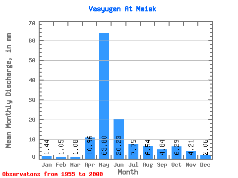
| Statistic | Jan | Feb | Mar | Apr | May | Jun | Jul | Aug | Sep | Oct | Nov | Dec | Annual |
|---|---|---|---|---|---|---|---|---|---|---|---|---|---|
| Mean | 1.44 | 1.06 | 1.08 | 10.96 | 63.80 | 20.23 | 7.75 | 6.54 | 4.84 | 6.29 | 4.21 | 2.06 | 129.34 |
| Standard Deviation | 0.71 | 0.31 | 0.26 | 10.63 | 31.62 | 15.51 | 9.45 | 6.63 | 4.28 | 4.83 | 3.34 | 1.19 | 56.89 |
| Min | 0.39 | 0.37 | 0.45 | 0.94 | 4.28 | 2.45 | 1.21 | 1.07 | 1.12 | 1.18 | 1.05 | 0.73 | 22.25 |
| Max | 3.98 | 1.77 | 1.68 | 43.36 | 129.23 | 70.88 | 39.70 | 26.71 | 16.96 | 17.88 | 15.71 | 5.21 | 251.90 |
| Coefficient of Variation | 0.49 | 0.30 | 0.24 | 0.97 | 0.50 | 0.77 | 1.22 | 1.01 | 0.88 | 0.77 | 0.79 | 0.58 | 0.44 |
 Return to R-Arctic Net Home Page