|
|
|||||||||||||||||
| Point ID: 6858 | Downloads | Plots | Site Data | Code: 10475 |
|
|
|||||||||||||||||
| Download | |
|---|---|
| Site Descriptor Information | Site Time Series Data |
| Link to all available data | |
| View: | Time Series | All |
| Units: | mm |
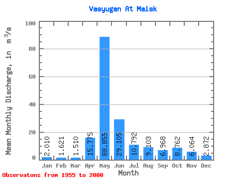
| Statistic | Jan | Feb | Mar | Apr | May | Jun | Jul | Aug | Sep | Oct | Nov | Dec | Annual |
|---|---|---|---|---|---|---|---|---|---|---|---|---|---|
| Mean | 2.01 | 1.62 | 1.51 | 15.78 | 88.86 | 29.11 | 10.79 | 9.10 | 6.97 | 8.76 | 6.06 | 2.87 | 15.29 |
| Standard Deviation | 0.99 | 0.48 | 0.36 | 15.30 | 44.04 | 22.32 | 13.16 | 9.23 | 6.16 | 6.72 | 4.80 | 1.65 | 6.72 |
| Min | 0.54 | 0.57 | 0.62 | 1.36 | 5.96 | 3.53 | 1.68 | 1.49 | 1.61 | 1.64 | 1.51 | 1.02 | 2.63 |
| Max | 5.55 | 2.71 | 2.34 | 62.40 | 180.00 | 102.00 | 55.30 | 37.20 | 24.40 | 24.90 | 22.60 | 7.25 | 29.77 |
| Coefficient of Variation | 0.49 | 0.30 | 0.24 | 0.97 | 0.50 | 0.77 | 1.22 | 1.01 | 0.88 | 0.77 | 0.79 | 0.58 | 0.44 |
 Return to R-Arctic Net Home Page