|
|
|||||||||||||||||
| Point ID: 6852 | Downloads | Plots | Site Data | Code: 10461 |
|
|
|||||||||||||||||
| Download | |
|---|---|
| Site Descriptor Information | Site Time Series Data |
| Link to all available data | |
| View: | Time Series | All |
| Units: | m3/s |
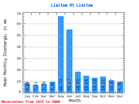
| Statistic | Jan | Feb | Mar | Apr | May | Jun | Jul | Aug | Sep | Oct | Nov | Dec | Annual |
|---|---|---|---|---|---|---|---|---|---|---|---|---|---|
| Mean | 8.63 | 7.07 | 7.78 | 9.42 | 66.72 | 55.17 | 18.50 | 15.03 | 13.18 | 14.21 | 10.87 | 9.35 | 234.88 |
| Standard Deviation | 3.83 | 2.72 | 3.53 | 3.83 | 22.20 | 26.97 | 5.25 | 4.59 | 4.21 | 4.38 | 3.83 | 4.00 | 54.74 |
| Min | 4.05 | 4.21 | 4.59 | 5.13 | 32.72 | 20.59 | 10.31 | 8.00 | 5.20 | 5.48 | 5.54 | 4.12 | 144.04 |
| Max | 21.77 | 17.66 | 21.52 | 21.03 | 114.16 | 128.05 | 33.36 | 24.79 | 22.17 | 26.07 | 23.65 | 22.87 | 344.27 |
| Coefficient of Variation | 0.44 | 0.38 | 0.45 | 0.41 | 0.33 | 0.49 | 0.28 | 0.31 | 0.32 | 0.31 | 0.35 | 0.43 | 0.23 |
 Return to R-Arctic Net Home Page