|
|
|||||||||||||||||
| Point ID: 6852 | Downloads | Plots | Site Data | Code: 10461 |
|
|
|||||||||||||||||
| Download | |
|---|---|
| Site Descriptor Information | Site Time Series Data |
| Link to all available data | |
| View: | Time Series | All |
| Units: | mm |
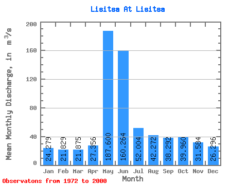
| Statistic | Jan | Feb | Mar | Apr | May | Jun | Jul | Aug | Sep | Oct | Nov | Dec | Annual |
|---|---|---|---|---|---|---|---|---|---|---|---|---|---|
| Mean | 24.28 | 21.83 | 21.88 | 27.36 | 187.60 | 160.26 | 52.00 | 42.27 | 38.29 | 39.96 | 31.58 | 26.30 | 56.04 |
| Standard Deviation | 10.77 | 8.39 | 9.92 | 11.12 | 62.44 | 78.36 | 14.77 | 12.92 | 12.24 | 12.32 | 11.13 | 11.23 | 13.06 |
| Min | 11.40 | 13.00 | 12.90 | 14.90 | 92.00 | 59.80 | 29.00 | 22.50 | 15.10 | 15.40 | 16.10 | 11.60 | 34.37 |
| Max | 61.20 | 54.50 | 60.50 | 61.10 | 321.00 | 372.00 | 93.80 | 69.70 | 64.40 | 73.30 | 68.70 | 64.30 | 82.14 |
| Coefficient of Variation | 0.44 | 0.38 | 0.45 | 0.41 | 0.33 | 0.49 | 0.28 | 0.31 | 0.32 | 0.31 | 0.35 | 0.43 | 0.23 |
 Return to R-Arctic Net Home Page