|
|
|||||||||||||||||
| Point ID: 6845 | Downloads | Plots | Site Data | Code: 10441 |
|
|
|||||||||||||||||
| Download | |
|---|---|
| Site Descriptor Information | Site Time Series Data |
| Link to all available data | |
| View: | Time Series | All |
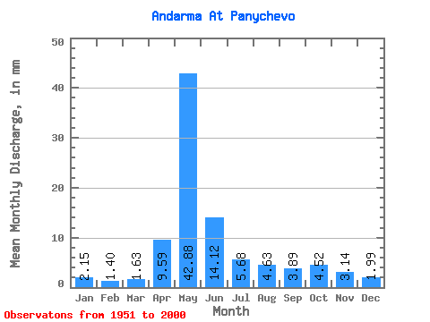
| Units: | m3/s |
| Statistic | Jan | Feb | Mar | Apr | May | Jun | Jul | Aug | Sep | Oct | Nov | Dec | Annual |
|---|---|---|---|---|---|---|---|---|---|---|---|---|---|
| Mean | 2.15 | 1.41 | 1.63 | 9.59 | 42.88 | 14.12 | 5.68 | 4.63 | 3.89 | 4.52 | 3.14 | 1.99 | 95.04 |
| Standard Deviation | 2.98 | 0.27 | 0.33 | 10.26 | 27.76 | 10.91 | 6.97 | 5.69 | 3.72 | 3.42 | 1.79 | 0.66 | 50.41 |
| Min | 0.72 | 0.88 | 0.85 | 1.90 | 4.14 | 2.15 | 1.34 | 1.07 | 1.39 | 1.38 | 1.06 | 0.57 | 26.57 |
| Max | 21.49 | 2.01 | 2.58 | 54.40 | 114.59 | 48.39 | 37.35 | 28.73 | 23.14 | 16.90 | 8.96 | 3.78 | 277.72 |
| Coefficient of Variation | 1.39 | 0.19 | 0.20 | 1.07 | 0.65 | 0.77 | 1.23 | 1.23 | 0.96 | 0.76 | 0.57 | 0.33 | 0.53 |
 Return to R-Arctic Net Home Page