|
|
|||||||||||||||||
| Point ID: 6845 | Downloads | Plots | Site Data | Code: 10441 |
|
|
|||||||||||||||||
| Download | |
|---|---|
| Site Descriptor Information | Site Time Series Data |
| Link to all available data | |
| View: | Time Series | All |
| Units: | mm |
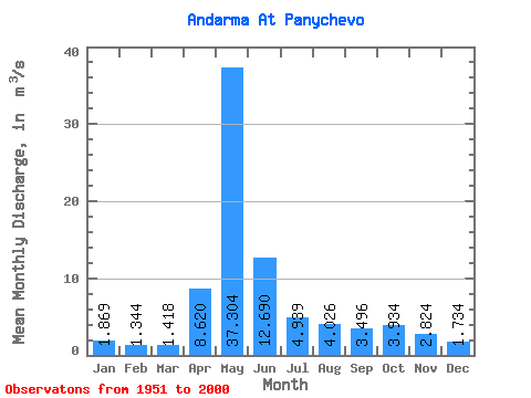
| Statistic | Jan | Feb | Mar | Apr | May | Jun | Jul | Aug | Sep | Oct | Nov | Dec | Annual |
|---|---|---|---|---|---|---|---|---|---|---|---|---|---|
| Mean | 1.87 | 1.34 | 1.42 | 8.62 | 37.30 | 12.69 | 4.94 | 4.03 | 3.50 | 3.93 | 2.82 | 1.73 | 7.02 |
| Standard Deviation | 2.59 | 0.26 | 0.29 | 9.22 | 24.15 | 9.81 | 6.07 | 4.95 | 3.35 | 2.98 | 1.61 | 0.57 | 3.72 |
| Min | 0.63 | 0.84 | 0.74 | 1.71 | 3.60 | 1.93 | 1.17 | 0.93 | 1.25 | 1.20 | 0.95 | 0.50 | 1.96 |
| Max | 18.70 | 1.92 | 2.24 | 48.90 | 99.70 | 43.50 | 32.50 | 25.00 | 20.80 | 14.70 | 8.05 | 3.29 | 20.50 |
| Coefficient of Variation | 1.39 | 0.19 | 0.20 | 1.07 | 0.65 | 0.77 | 1.23 | 1.23 | 0.96 | 0.76 | 0.57 | 0.33 | 0.53 |
 Return to R-Arctic Net Home Page