|
|
|||||||||||||||||
| Point ID: 6838 | Downloads | Plots | Site Data | Code: 10428 |
|
|
|||||||||||||||||
| Download | |
|---|---|
| Site Descriptor Information | Site Time Series Data |
| Link to all available data | |
| View: | Time Series | All |
| Units: | m3/s |
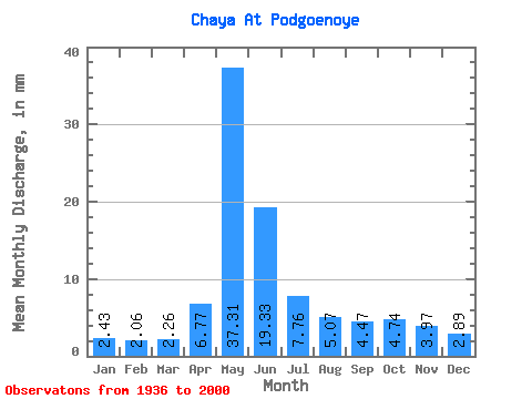
| Statistic | Jan | Feb | Mar | Apr | May | Jun | Jul | Aug | Sep | Oct | Nov | Dec | Annual |
|---|---|---|---|---|---|---|---|---|---|---|---|---|---|
| Mean | 2.43 | 2.08 | 2.26 | 6.77 | 37.30 | 19.33 | 7.76 | 5.07 | 4.46 | 4.74 | 3.97 | 2.89 | 95.77 |
| Standard Deviation | 0.51 | 0.43 | 0.42 | 5.55 | 20.96 | 14.47 | 7.09 | 3.35 | 2.91 | 2.63 | 2.00 | 0.86 | 44.43 |
| Min | 1.67 | 1.39 | 1.49 | 2.09 | 5.43 | 2.67 | 2.47 | 1.67 | 1.59 | 1.71 | 1.96 | 1.65 | 34.24 |
| Max | 3.88 | 3.31 | 3.32 | 29.76 | 84.20 | 70.71 | 37.28 | 16.93 | 15.97 | 14.35 | 10.68 | 5.51 | 225.93 |
| Coefficient of Variation | 0.21 | 0.21 | 0.18 | 0.82 | 0.56 | 0.75 | 0.91 | 0.66 | 0.65 | 0.55 | 0.51 | 0.30 | 0.46 |
 Return to R-Arctic Net Home Page