|
|
|||||||||||||||||
| Point ID: 6838 | Downloads | Plots | Site Data | Code: 10428 |
|
|
|||||||||||||||||
| Download | |
|---|---|
| Site Descriptor Information | Site Time Series Data |
| Link to all available data | |
| View: | Time Series | All |
| Units: | mm |
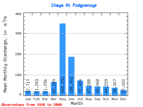
| Statistic | Jan | Feb | Mar | Apr | May | Jun | Jul | Aug | Sep | Oct | Nov | Dec | Annual |
|---|---|---|---|---|---|---|---|---|---|---|---|---|---|
| Mean | 22.72 | 21.26 | 21.10 | 65.29 | 348.23 | 186.45 | 72.42 | 47.29 | 43.07 | 44.24 | 38.31 | 27.00 | 75.86 |
| Standard Deviation | 4.76 | 4.43 | 3.89 | 53.57 | 195.63 | 139.57 | 66.21 | 31.25 | 28.04 | 24.53 | 19.33 | 7.99 | 35.20 |
| Min | 15.60 | 14.20 | 13.90 | 20.20 | 50.70 | 25.70 | 23.10 | 15.60 | 15.30 | 16.00 | 18.90 | 15.40 | 27.12 |
| Max | 36.20 | 33.90 | 31.00 | 287.00 | 786.00 | 682.00 | 348.00 | 158.00 | 154.00 | 134.00 | 103.00 | 51.40 | 178.97 |
| Coefficient of Variation | 0.21 | 0.21 | 0.18 | 0.82 | 0.56 | 0.75 | 0.91 | 0.66 | 0.65 | 0.55 | 0.51 | 0.30 | 0.46 |
 Return to R-Arctic Net Home Page