|
|
|||||||||||||||||
| Point ID: 6836 | Downloads | Plots | Site Data | Code: 10424 |
|
|
|||||||||||||||||
| Download | |
|---|---|
| Site Descriptor Information | Site Time Series Data |
| Link to all available data | |
| View: | Time Series | All |
| Units: | m3/s |
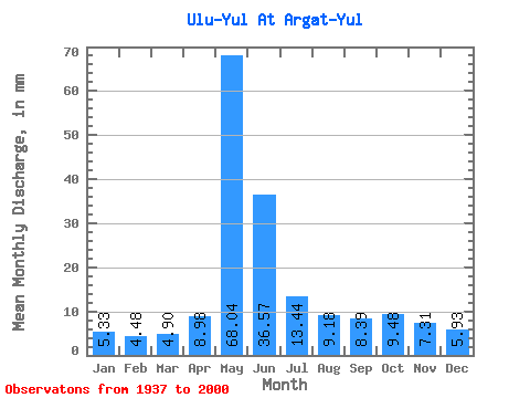
| Statistic | Jan | Feb | Mar | Apr | May | Jun | Jul | Aug | Sep | Oct | Nov | Dec | Annual |
|---|---|---|---|---|---|---|---|---|---|---|---|---|---|
| Mean | 5.33 | 4.52 | 4.90 | 8.98 | 68.03 | 36.57 | 13.44 | 9.18 | 8.39 | 9.47 | 7.31 | 5.93 | 179.57 |
| Standard Deviation | 0.84 | 0.70 | 0.80 | 5.46 | 24.75 | 17.70 | 5.98 | 2.54 | 2.62 | 4.26 | 2.61 | 1.24 | 43.95 |
| Min | 3.46 | 2.61 | 2.24 | 2.68 | 24.11 | 9.27 | 6.04 | 5.38 | 5.34 | 5.31 | 4.83 | 3.18 | 96.38 |
| Max | 7.77 | 6.32 | 6.63 | 27.83 | 130.78 | 79.57 | 38.16 | 16.23 | 14.44 | 29.28 | 17.93 | 8.98 | 269.61 |
| Coefficient of Variation | 0.16 | 0.15 | 0.16 | 0.61 | 0.36 | 0.48 | 0.45 | 0.28 | 0.31 | 0.45 | 0.36 | 0.21 | 0.24 |
 Return to R-Arctic Net Home Page