|
|
|||||||||||||||||
| Point ID: 6836 | Downloads | Plots | Site Data | Code: 10424 |
|
|
|||||||||||||||||
| Download | |
|---|---|
| Site Descriptor Information | Site Time Series Data |
| Link to all available data | |
| View: | Time Series | All |
| Units: | mm |
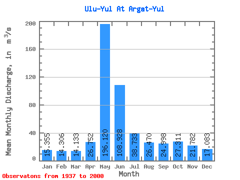
| Statistic | Jan | Feb | Mar | Apr | May | Jun | Jul | Aug | Sep | Oct | Nov | Dec | Annual |
|---|---|---|---|---|---|---|---|---|---|---|---|---|---|
| Mean | 15.36 | 14.31 | 14.13 | 26.75 | 196.12 | 108.93 | 38.73 | 26.47 | 25.00 | 27.31 | 21.78 | 17.08 | 43.92 |
| Standard Deviation | 2.42 | 2.22 | 2.31 | 16.26 | 71.33 | 52.72 | 17.25 | 7.33 | 7.81 | 12.30 | 7.76 | 3.56 | 10.75 |
| Min | 9.97 | 8.26 | 6.46 | 7.97 | 69.50 | 27.60 | 17.40 | 15.50 | 15.90 | 15.30 | 14.40 | 9.16 | 23.57 |
| Max | 22.40 | 20.00 | 19.10 | 82.90 | 377.00 | 237.00 | 110.00 | 46.80 | 43.00 | 84.40 | 53.40 | 25.90 | 65.95 |
| Coefficient of Variation | 0.16 | 0.15 | 0.16 | 0.61 | 0.36 | 0.48 | 0.45 | 0.28 | 0.31 | 0.45 | 0.36 | 0.21 | 0.24 |
 Return to R-Arctic Net Home Page