|
|
|||||||||||||||||
| Point ID: 6835 | Downloads | Plots | Site Data | Code: 10423 |
|
|
|||||||||||||||||
| Download | |
|---|---|
| Site Descriptor Information | Site Time Series Data |
| Link to all available data | |
| View: | Time Series | All |
| Units: | m3/s |
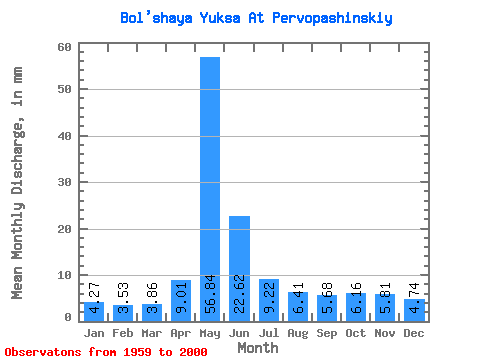
| Statistic | Jan | Feb | Mar | Apr | May | Jun | Jul | Aug | Sep | Oct | Nov | Dec | Annual |
|---|---|---|---|---|---|---|---|---|---|---|---|---|---|
| Mean | 4.27 | 3.56 | 3.85 | 9.01 | 56.83 | 22.62 | 9.22 | 6.41 | 5.67 | 6.16 | 5.81 | 4.74 | 137.49 |
| Standard Deviation | 0.82 | 0.74 | 0.87 | 6.08 | 19.74 | 13.68 | 6.45 | 2.68 | 1.77 | 1.79 | 2.43 | 1.32 | 36.46 |
| Min | 2.20 | 1.93 | 2.01 | 3.29 | 13.70 | 5.76 | 3.88 | 3.39 | 3.13 | 3.26 | 1.75 | 1.22 | 62.87 |
| Max | 5.71 | 5.21 | 5.78 | 32.55 | 93.63 | 53.72 | 39.56 | 16.46 | 10.69 | 11.04 | 14.44 | 7.46 | 203.13 |
| Coefficient of Variation | 0.19 | 0.21 | 0.23 | 0.68 | 0.35 | 0.60 | 0.70 | 0.42 | 0.31 | 0.29 | 0.42 | 0.28 | 0.27 |
 Return to R-Arctic Net Home Page