|
|
|||||||||||||||||
| Point ID: 6835 | Downloads | Plots | Site Data | Code: 10423 |
|
|
|||||||||||||||||
| Download | |
|---|---|
| Site Descriptor Information | Site Time Series Data |
| Link to all available data | |
| View: | Time Series | All |
| Units: | mm |
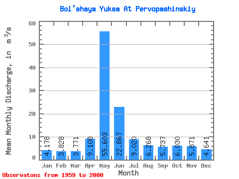
| Statistic | Jan | Feb | Mar | Apr | May | Jun | Jul | Aug | Sep | Oct | Nov | Dec | Annual |
|---|---|---|---|---|---|---|---|---|---|---|---|---|---|
| Mean | 4.18 | 3.83 | 3.77 | 9.11 | 55.60 | 22.87 | 9.02 | 6.27 | 5.74 | 6.03 | 5.87 | 4.64 | 11.41 |
| Standard Deviation | 0.81 | 0.80 | 0.85 | 6.15 | 19.31 | 13.83 | 6.31 | 2.62 | 1.79 | 1.75 | 2.46 | 1.29 | 3.03 |
| Min | 2.15 | 2.07 | 1.97 | 3.33 | 13.40 | 5.82 | 3.80 | 3.32 | 3.16 | 3.19 | 1.77 | 1.19 | 5.22 |
| Max | 5.59 | 5.60 | 5.65 | 32.90 | 91.60 | 54.30 | 38.70 | 16.10 | 10.80 | 10.80 | 14.60 | 7.30 | 16.86 |
| Coefficient of Variation | 0.19 | 0.21 | 0.23 | 0.68 | 0.35 | 0.60 | 0.70 | 0.42 | 0.31 | 0.29 | 0.42 | 0.28 | 0.27 |
 Return to R-Arctic Net Home Page