|
|
|||||||||||||||||
| Point ID: 6828 | Downloads | Plots | Site Data | Code: 10411 |
|
|
|||||||||||||||||
| Download | |
|---|---|
| Site Descriptor Information | Site Time Series Data |
| Link to all available data | |
| View: | Time Series | All |
| Units: | m3/s |
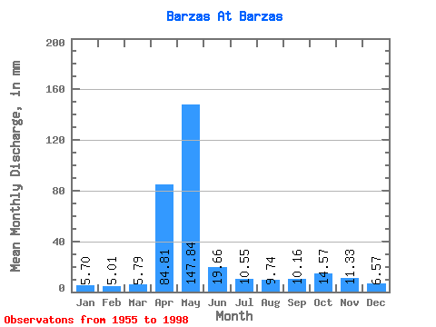
| Statistic | Jan | Feb | Mar | Apr | May | Jun | Jul | Aug | Sep | Oct | Nov | Dec | Annual |
|---|---|---|---|---|---|---|---|---|---|---|---|---|---|
| Mean | 5.70 | 5.05 | 5.79 | 84.81 | 147.82 | 19.66 | 10.55 | 9.74 | 10.16 | 14.56 | 11.33 | 6.57 | 330.37 |
| Standard Deviation | 2.52 | 2.40 | 2.26 | 49.61 | 89.42 | 14.09 | 5.10 | 4.83 | 5.21 | 8.12 | 5.92 | 2.59 | 86.36 |
| Min | 1.67 | 1.70 | 1.52 | 8.95 | 21.90 | 4.99 | 4.27 | 3.46 | 2.69 | 4.27 | 3.08 | 1.74 | 178.62 |
| Max | 13.64 | 11.35 | 10.21 | 172.88 | 351.17 | 65.29 | 29.05 | 23.90 | 26.41 | 46.74 | 26.90 | 13.31 | 557.11 |
| Coefficient of Variation | 0.44 | 0.47 | 0.39 | 0.58 | 0.60 | 0.72 | 0.48 | 0.50 | 0.51 | 0.56 | 0.52 | 0.39 | 0.26 |
 Return to R-Arctic Net Home Page