|
|
|||||||||||||||||
| Point ID: 6828 | Downloads | Plots | Site Data | Code: 10411 |
|
|
|||||||||||||||||
| Download | |
|---|---|
| Site Descriptor Information | Site Time Series Data |
| Link to all available data | |
|
|
| View: | Statistics | Time Series |
| Units: | m3/s |
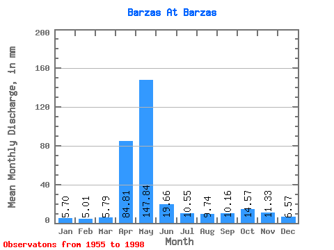
| Statistic | Jan | Feb | Mar | Apr | May | Jun | Jul | Aug | Sep | Oct | Nov | Dec | Annual |
|---|---|---|---|---|---|---|---|---|---|---|---|---|---|
| Mean | 5.70 | 5.05 | 5.79 | 84.81 | 147.82 | 19.66 | 10.55 | 9.74 | 10.16 | 14.56 | 11.33 | 6.57 | 330.37 |
| Standard Deviation | 2.52 | 2.40 | 2.26 | 49.61 | 89.42 | 14.09 | 5.10 | 4.83 | 5.21 | 8.12 | 5.92 | 2.59 | 86.36 |
| Min | 1.67 | 1.70 | 1.52 | 8.95 | 21.90 | 4.99 | 4.27 | 3.46 | 2.69 | 4.27 | 3.08 | 1.74 | 178.62 |
| Max | 13.64 | 11.35 | 10.21 | 172.88 | 351.17 | 65.29 | 29.05 | 23.90 | 26.41 | 46.74 | 26.90 | 13.31 | 557.11 |
| Coefficient of Variation | 0.44 | 0.47 | 0.39 | 0.58 | 0.60 | 0.72 | 0.48 | 0.50 | 0.51 | 0.56 | 0.52 | 0.39 | 0.26 |
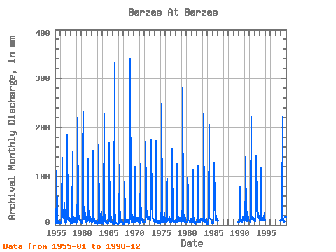
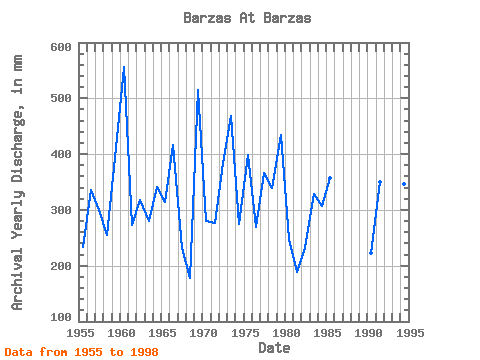
| Year | Jan | Feb | Mar | Apr | May | Jun | Jul | Aug | Sep | Oct | Nov | Dec | Annual | 1955 | 4.04 | 4.14 | 3.61 | 65.78 | 114.95 | 5.26 | 5.28 | 3.89 | 9.05 | 8.72 | 3.84 | 6.32 | 233.80 | 1956 | 3.56 | 3.13 | 3.66 | 29.59 | 142.74 | 35.70 | 17.25 | 13.64 | 15.87 | 46.74 | 21.32 | 5.53 | 336.32 | 1957 | 5.74 | 3.94 | 4.65 | 15.94 | 192.26 | 22.52 | 10.46 | 10.26 | 7.58 | 15.13 | 9.85 | 4.57 | 299.67 | 1958 | 3.84 | 2.74 | 3.28 | 11.00 | 154.36 | 29.34 | 8.03 | 10.23 | 6.24 | 15.01 | 7.56 | 5.68 | 254.74 | 1959 | 4.04 | 4.72 | 4.47 | 76.05 | 227.38 | 26.16 | 13.06 | 17.08 | 10.12 | 12.38 | 10.12 | 8.01 | 410.63 | 1960 | 4.50 | 3.59 | 3.66 | 141.83 | 240.26 | 65.29 | 12.20 | 18.21 | 26.41 | 25.52 | 11.81 | 5.51 | 557.11 | 1961 | 5.76 | 5.50 | 7.66 | 135.96 | 50.53 | 9.81 | 6.34 | 7.50 | 12.47 | 17.00 | 7.78 | 6.37 | 273.72 | 1962 | 5.53 | 4.58 | 7.91 | 153.32 | 92.21 | 15.11 | 11.17 | 3.97 | 6.55 | 10.08 | 3.08 | 3.54 | 317.61 | 1963 | 2.88 | 2.35 | 3.74 | 11.25 | 170.53 | 6.48 | 4.27 | 6.19 | 19.73 | 22.03 | 26.90 | 5.96 | 279.57 | 1964 | 4.22 | 2.74 | 2.70 | 23.50 | 236.98 | 33.50 | 8.97 | 5.66 | 5.50 | 8.99 | 7.26 | 4.17 | 340.56 | 1965 | 3.54 | 2.90 | 3.87 | 78.49 | 174.32 | 8.68 | 5.28 | 6.92 | 15.94 | 7.86 | 4.67 | 3.03 | 313.64 | 1966 | 3.03 | 2.35 | 1.52 | 8.95 | 343.59 | 38.88 | 6.29 | 4.62 | 3.33 | 4.27 | 3.11 | 1.74 | 416.11 | 1967 | 1.67 | 2.26 | 3.87 | 123.49 | 44.21 | 12.69 | 7.78 | 7.28 | 10.15 | 9.98 | 4.55 | 2.48 | 231.39 | 1968 | 2.42 | 2.00 | 8.82 | 88.03 | 21.90 | 5.58 | 9.02 | 5.61 | 10.69 | 8.79 | 10.17 | 4.85 | 178.62 | 1969 | 5.86 | 3.22 | 3.38 | 73.60 | 351.17 | 17.70 | 4.50 | 8.62 | 6.97 | 22.84 | 14.38 | 7.91 | 514.81 | 1970 | 6.04 | 5.11 | 6.37 | 119.57 | 64.93 | 8.53 | 12.23 | 16.22 | 8.09 | 15.29 | 12.57 | 5.25 | 280.52 | 1971 | 5.94 | 7.71 | 4.40 | 125.20 | 63.41 | 13.45 | 12.35 | 10.91 | 8.14 | 7.25 | 10.66 | 6.47 | 276.82 | 1972 | 5.56 | 5.00 | 6.47 | 169.70 | 69.22 | 43.77 | 16.25 | 11.97 | 11.91 | 12.03 | 17.29 | 13.31 | 384.00 | 1973 | 13.64 | 11.35 | 9.35 | 137.67 | 181.14 | 35.70 | 29.05 | 18.44 | 7.26 | 8.62 | 10.05 | 7.00 | 468.17 | 1974 | 5.89 | 5.62 | 5.96 | 172.88 | 39.41 | 6.97 | 4.42 | 3.46 | 9.22 | 9.83 | 5.60 | 4.32 | 275.56 | 1975 | 5.00 | 4.00 | 4.47 | 46.70 | 257.69 | 23.50 | 6.64 | 5.86 | 5.09 | 12.96 | 24.70 | 5.41 | 398.47 | 1976 | 6.29 | 4.14 | 5.36 | 84.36 | 98.03 | 7.21 | 11.77 | 11.65 | 9.27 | 17.08 | 8.22 | 7.15 | 269.62 | 1977 | 6.44 | 4.79 | 5.68 | 156.99 | 146.03 | 8.44 | 6.59 | 4.90 | 4.77 | 6.42 | 9.73 | 6.09 | 366.61 | 1978 | 5.66 | 5.13 | 4.95 | 125.44 | 103.08 | 19.00 | 19.18 | 12.96 | 8.36 | 12.05 | 14.96 | 8.49 | 339.15 | 1979 | 6.54 | 6.47 | 7.83 | 52.33 | 290.54 | 13.40 | 7.55 | 8.87 | 7.02 | 21.42 | 9.83 | 8.01 | 435.24 | 1980 | 7.20 | 5.48 | 7.12 | 97.32 | 70.74 | 11.10 | 9.57 | 7.07 | 5.94 | 5.84 | 13.55 | 6.85 | 248.04 | 1981 | 5.20 | 4.40 | 4.93 | 114.19 | 26.02 | 4.99 | 4.60 | 4.24 | 2.69 | 5.86 | 5.75 | 5.28 | 189.36 | 1982 | 4.70 | 4.21 | 5.28 | 122.51 | 29.05 | 8.02 | 10.56 | 6.97 | 5.26 | 13.92 | 11.62 | 9.50 | 232.66 | 1983 | 8.13 | 7.67 | 8.77 | 16.75 | 234.20 | 13.38 | 7.02 | 6.06 | 6.28 | 7.88 | 12.96 | 3.51 | 329.00 | 1984 | 2.35 | 1.70 | 3.84 | 12.96 | 212.72 | 15.53 | 14.58 | 12.40 | 12.25 | 11.82 | 6.80 | 3.49 | 306.59 | 1985 | 3.11 | 3.94 | 4.37 | 81.92 | 131.37 | 47.44 | 11.24 | 23.90 | 15.04 | 16.27 | 11.22 | 8.99 | 357.83 | 1990 | 6.42 | 7.21 | 7.78 | 79.72 | 53.81 | 7.95 | 9.47 | 8.26 | 6.21 | 17.25 | 9.59 | 8.97 | 222.71 | 1991 | 8.49 | 8.29 | 9.17 | 86.32 | 144.51 | 12.30 | 10.96 | 8.84 | 14.84 | 27.29 | 11.30 | 9.17 | 350.04 | 1992 | 8.94 | 7.09 | 7.30 | 45.73 | 228.64 | 24.45 | 13.21 | 12.35 | 18.17 | 13.85 | 10.64 | 8.92 | 396.04 | 1993 | 7.83 | 7.80 | 7.98 | 101.48 | 145.52 | 35.46 | 19.23 | 15.97 | 19.39 | 25.77 | 13.38 | 11.09 | 409.81 | 1994 | 11.80 | 8.72 | 10.21 | 117.86 | 92.47 | 15.21 | 13.79 | 11.37 | 14.57 | 13.92 | 25.68 | 11.02 | 346.89 | 1998 | 8.97 | 11.07 | 9.80 | 33.50 | 229.40 | 18.73 | 10.01 | 7.93 | 9.63 | 20.94 | 16.70 | 8.99 | 382.39 |
|---|
 Return to R-Arctic Net Home Page