|
|
|||||||||||||||||
| Point ID: 6777 | Downloads | Plots | Site Data | Code: 10289 |
|
|
|||||||||||||||||
| Download | |
|---|---|
| Site Descriptor Information | Site Time Series Data |
| Link to all available data | |
| View: | Time Series | All |
| Units: | m3/s |
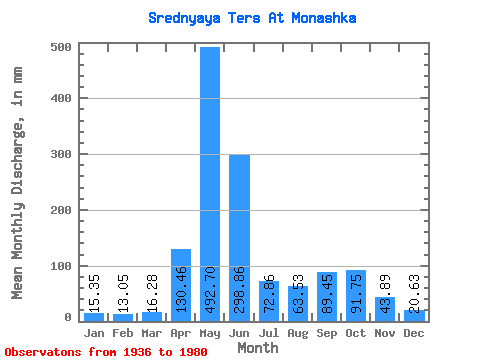
| Statistic | Jan | Feb | Mar | Apr | May | Jun | Jul | Aug | Sep | Oct | Nov | Dec | Annual |
|---|---|---|---|---|---|---|---|---|---|---|---|---|---|
| Mean | 15.35 | 13.16 | 16.27 | 130.46 | 492.63 | 298.86 | 72.84 | 63.52 | 89.45 | 91.74 | 43.89 | 20.62 | 1344.23 |
| Standard Deviation | 6.22 | 7.72 | 12.20 | 79.45 | 110.12 | 168.27 | 31.13 | 23.59 | 48.26 | 36.70 | 17.48 | 8.08 | 235.32 |
| Min | 4.69 | 5.42 | 7.03 | 35.40 | 282.20 | 79.71 | 34.41 | 21.16 | 19.23 | 35.42 | 19.37 | 7.93 | 970.30 |
| Max | 34.12 | 44.73 | 74.72 | 401.34 | 753.01 | 645.21 | 140.24 | 116.62 | 186.74 | 205.89 | 102.70 | 40.60 | 1885.96 |
| Coefficient of Variation | 0.41 | 0.59 | 0.75 | 0.61 | 0.22 | 0.56 | 0.43 | 0.37 | 0.54 | 0.40 | 0.40 | 0.39 | 0.17 |
 Return to R-Arctic Net Home Page