|
|
|||||||||||||||||
| Point ID: 6777 | Downloads | Plots | Site Data | Code: 10289 |
|
|
|||||||||||||||||
| Download | |
|---|---|
| Site Descriptor Information | Site Time Series Data |
| Link to all available data | |
|
|
| View: | Statistics | Time Series |
| Units: | m3/s |
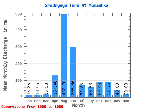
| Statistic | Jan | Feb | Mar | Apr | May | Jun | Jul | Aug | Sep | Oct | Nov | Dec | Annual |
|---|---|---|---|---|---|---|---|---|---|---|---|---|---|
| Mean | 15.35 | 13.16 | 16.27 | 130.46 | 492.63 | 298.86 | 72.84 | 63.52 | 89.45 | 91.74 | 43.89 | 20.62 | 1344.23 |
| Standard Deviation | 6.22 | 7.72 | 12.20 | 79.45 | 110.12 | 168.27 | 31.13 | 23.59 | 48.26 | 36.70 | 17.48 | 8.08 | 235.32 |
| Min | 4.69 | 5.42 | 7.03 | 35.40 | 282.20 | 79.71 | 34.41 | 21.16 | 19.23 | 35.42 | 19.37 | 7.93 | 970.30 |
| Max | 34.12 | 44.73 | 74.72 | 401.34 | 753.01 | 645.21 | 140.24 | 116.62 | 186.74 | 205.89 | 102.70 | 40.60 | 1885.96 |
| Coefficient of Variation | 0.41 | 0.59 | 0.75 | 0.61 | 0.22 | 0.56 | 0.43 | 0.37 | 0.54 | 0.40 | 0.40 | 0.39 | 0.17 |
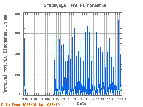
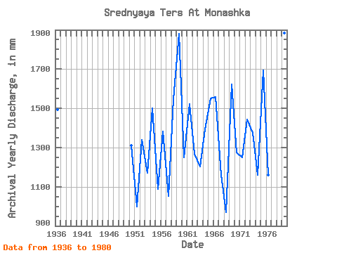
| Year | Jan | Feb | Mar | Apr | May | Jun | Jul | Aug | Sep | Oct | Nov | Dec | Annual | 1936 | 21.74 | 23.48 | 23.18 | 35.40 | 359.95 | 540.70 | 112.59 | 106.54 | 133.36 | 66.95 | 47.66 | 21.31 | 1493.02 | 1950 | 11.96 | 11.43 | 17.13 | 92.53 | 606.15 | 185.34 | 38.59 | 82.50 | 158.87 | 72.56 | 28.57 | 12.70 | 1310.96 | 1951 | 10.37 | 5.56 | 7.92 | 129.74 | 492.41 | 95.74 | 49.38 | 56.44 | 51.56 | 57.88 | 31.91 | 19.15 | 1000.59 | 1952 | 15.26 | 10.55 | 10.19 | 44.31 | 561.52 | 281.50 | 135.63 | 68.10 | 40.97 | 124.25 | 41.39 | 17.57 | 1341.33 | 1953 | 13.79 | 9.71 | 14.54 | 209.03 | 496.73 | 147.72 | 45.21 | 52.98 | 57.97 | 85.52 | 26.76 | 17.13 | 1171.31 | 1954 | 15.84 | 13.90 | 12.83 | 77.20 | 282.20 | 491.92 | 134.91 | 84.95 | 176.98 | 97.47 | 102.70 | 7.93 | 1500.97 | 1955 | 4.69 | 5.42 | 7.03 | 161.65 | 512.56 | 89.47 | 35.13 | 21.16 | 168.62 | 46.07 | 20.35 | 23.18 | 1090.56 | 1956 | 11.36 | 11.15 | 10.58 | 130.99 | 548.56 | 253.63 | 59.90 | 55.29 | 101.45 | 158.38 | 34.98 | 14.69 | 1384.06 | 1957 | 14.28 | 10.29 | 9.16 | 55.88 | 465.05 | 241.08 | 50.68 | 43.05 | 34.70 | 74.00 | 40.27 | 19.87 | 1052.45 | 1958 | 15.12 | 17.18 | 14.97 | 97.97 | 581.67 | 498.89 | 92.87 | 52.55 | 43.90 | 67.09 | 43.62 | 25.34 | 1547.32 | 1959 | 13.30 | 9.16 | 9.04 | 232.72 | 670.94 | 585.29 | 81.06 | 59.17 | 88.35 | 89.27 | 27.45 | 18.14 | 1881.44 | 1960 | 14.69 | 9.63 | 8.49 | 58.39 | 394.50 | 358.14 | 110.29 | 65.08 | 130.57 | 56.58 | 30.38 | 16.84 | 1250.86 | 1961 | 17.42 | 12.10 | 27.50 | 401.34 | 459.29 | 206.25 | 68.39 | 56.58 | 120.96 | 86.53 | 40.97 | 26.64 | 1522.88 | 1962 | 15.55 | 10.06 | 14.97 | 186.74 | 562.96 | 168.62 | 57.73 | 28.51 | 43.62 | 154.06 | 19.37 | 13.99 | 1267.90 | 1963 | 10.94 | 8.59 | 12.01 | 62.43 | 453.53 | 231.33 | 42.33 | 37.29 | 142.14 | 108.27 | 78.32 | 19.44 | 1202.58 | 1964 | 13.26 | 11.27 | 10.41 | 63.69 | 636.38 | 377.65 | 71.84 | 43.34 | 42.23 | 61.19 | 38.18 | 31.82 | 1394.22 | 1965 | 16.56 | 12.69 | 16.99 | 170.01 | 692.54 | 164.44 | 34.41 | 49.24 | 186.74 | 139.80 | 64.38 | 13.29 | 1553.40 | 1966 | 17.85 | 9.46 | 13.55 | 43.34 | 596.07 | 645.21 | 88.98 | 31.82 | 19.23 | 35.42 | 47.24 | 12.53 | 1558.23 | 1967 | 10.15 | 8.21 | 9.82 | 282.89 | 393.06 | 116.64 | 67.24 | 46.22 | 89.47 | 109.14 | 22.30 | 10.09 | 1161.78 | 1968 | 10.14 | 7.45 | 22.61 | 168.62 | 332.59 | 79.71 | 93.59 | 60.90 | 61.59 | 73.28 | 36.79 | 28.51 | 970.30 | 1969 | 28.80 | 23.09 | 10.91 | 45.85 | 601.83 | 611.77 | 43.19 | 66.81 | 49.47 | 100.35 | 31.08 | 12.41 | 1622.68 | 1970 | 10.53 | 9.62 | 13.07 | 133.22 | 476.57 | 282.89 | 47.37 | 95.60 | 45.15 | 108.70 | 41.81 | 15.12 | 1274.02 | 1971 | 13.85 | 12.30 | 12.35 | 118.03 | 478.01 | 285.68 | 90.85 | 56.30 | 57.00 | 54.14 | 55.46 | 22.03 | 1251.48 | 1972 | 12.20 | 9.55 | 10.67 | 186.74 | 433.38 | 264.77 | 140.24 | 116.62 | 125.56 | 93.59 | 42.92 | 13.46 | 1444.82 | 1973 | 9.13 | 7.52 | 9.10 | 161.65 | 452.09 | 447.33 | 89.70 | 74.58 | 20.90 | 52.12 | 37.07 | 15.41 | 1374.37 | 1974 | 11.06 | 9.67 | 15.69 | 157.47 | 433.38 | 154.68 | 34.55 | 38.44 | 124.44 | 107.41 | 53.65 | 23.47 | 1159.96 | 1975 | 27.79 | 44.73 | 74.72 | 123.75 | 444.89 | 549.06 | 72.42 | 53.42 | 112.18 | 107.55 | 53.23 | 30.23 | 1695.22 | 1976 | 23.90 | 20.46 | 29.08 | 88.35 | 380.10 | 193.70 | 46.22 | 98.77 | 124.31 | 104.24 | 39.85 | 16.99 | 1161.58 | 1977 | 13.35 | 11.79 | 14.02 | 136.85 | 421.86 | 164.44 | 46.51 | 65.65 | 78.73 | 101.36 | 44.04 | 32.83 | 1126.09 | 1978 | 11.82 | 9.89 | 12.87 | 188.13 | 378.66 | 261.99 | 91.71 | 94.31 | 52.81 | 81.20 | 65.22 | 40.60 | 1285.58 | 1979 | 34.12 | 26.11 | 28.80 | 58.81 | 753.01 | 433.39 | 57.88 | 95.03 | 117.06 | 205.89 | 54.77 | 30.95 | 1885.96 | 1980 | 20.30 | 19.28 | 16.56 | 71.07 | 411.78 | 154.68 | 99.63 | 75.44 | 61.59 | 55.29 | 61.87 | 36.28 | 1077.59 |
|---|
 Return to R-Arctic Net Home Page