|
|
|||||||||||||||||
| Point ID: 6776 | Downloads | Plots | Site Data | Code: 10288 |
|
|
|||||||||||||||||
| Download | |
|---|---|
| Site Descriptor Information | Site Time Series Data |
| Link to all available data | |
| View: | Time Series | All |
| Units: | m3/s |
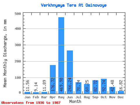
| Statistic | Jan | Feb | Mar | Apr | May | Jun | Jul | Aug | Sep | Oct | Nov | Dec | Annual |
|---|---|---|---|---|---|---|---|---|---|---|---|---|---|
| Mean | 11.56 | 9.22 | 11.89 | 176.72 | 469.90 | 266.24 | 70.73 | 60.24 | 82.72 | 92.72 | 42.48 | 16.82 | 1307.14 |
| Standard Deviation | 4.09 | 6.04 | 9.07 | 81.23 | 93.74 | 125.57 | 33.86 | 28.22 | 48.91 | 40.97 | 24.29 | 6.62 | 204.36 |
| Min | 7.27 | 4.81 | 5.12 | 9.63 | 255.46 | 56.16 | 26.52 | 24.13 | 13.19 | 26.52 | 10.47 | 7.48 | 779.67 |
| Max | 24.18 | 30.62 | 40.43 | 315.11 | 664.25 | 579.39 | 165.41 | 142.56 | 193.89 | 203.74 | 102.66 | 41.48 | 1806.42 |
| Coefficient of Variation | 0.35 | 0.66 | 0.76 | 0.46 | 0.20 | 0.47 | 0.48 | 0.47 | 0.59 | 0.44 | 0.57 | 0.39 | 0.16 |
 Return to R-Arctic Net Home Page