|
|
|||||||||||||||||
| Point ID: 6776 | Downloads | Plots | Site Data | Code: 10288 |
|
|
|||||||||||||||||
| Download | |
|---|---|
| Site Descriptor Information | Site Time Series Data |
| Link to all available data | |
| View: | Time Series | All |
| Units: | mm |
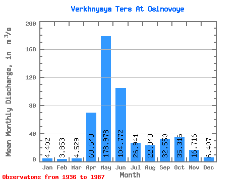
| Statistic | Jan | Feb | Mar | Apr | May | Jun | Jul | Aug | Sep | Oct | Nov | Dec | Annual |
|---|---|---|---|---|---|---|---|---|---|---|---|---|---|
| Mean | 4.40 | 3.85 | 4.53 | 69.54 | 178.98 | 104.77 | 26.94 | 22.94 | 32.55 | 35.32 | 16.72 | 6.41 | 42.25 |
| Standard Deviation | 1.56 | 2.52 | 3.46 | 31.97 | 35.70 | 49.41 | 12.90 | 10.75 | 19.25 | 15.60 | 9.56 | 2.52 | 6.61 |
| Min | 2.77 | 2.01 | 1.95 | 3.79 | 97.30 | 22.10 | 10.10 | 9.19 | 5.19 | 10.10 | 4.12 | 2.85 | 25.20 |
| Max | 9.21 | 12.80 | 15.40 | 124.00 | 253.00 | 228.00 | 63.00 | 54.30 | 76.30 | 77.60 | 40.40 | 15.80 | 58.38 |
| Coefficient of Variation | 0.35 | 0.66 | 0.76 | 0.46 | 0.20 | 0.47 | 0.48 | 0.47 | 0.59 | 0.44 | 0.57 | 0.39 | 0.16 |
 Return to R-Arctic Net Home Page