|
|
|||||||||||||||||
| Point ID: 6772 | Downloads | Plots | Site Data | Code: 10279 |
|
|
|||||||||||||||||
| Download | |
|---|---|
| Site Descriptor Information | Site Time Series Data |
| Link to all available data | |
| View: | Time Series | All |
| Units: | m3/s |
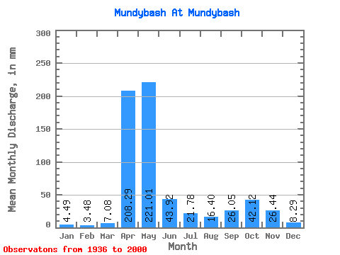
| Statistic | Jan | Feb | Mar | Apr | May | Jun | Jul | Aug | Sep | Oct | Nov | Dec | Annual |
|---|---|---|---|---|---|---|---|---|---|---|---|---|---|
| Mean | 4.49 | 3.51 | 7.08 | 208.29 | 220.98 | 43.92 | 21.78 | 16.40 | 26.05 | 42.11 | 26.44 | 8.28 | 628.33 |
| Standard Deviation | 2.42 | 1.87 | 6.93 | 75.24 | 120.96 | 35.90 | 23.96 | 14.77 | 23.50 | 30.17 | 26.60 | 5.19 | 140.96 |
| Min | 0.81 | 0.74 | 0.68 | 20.12 | 63.16 | 5.58 | 3.92 | 3.76 | 4.38 | 7.35 | 4.70 | 1.69 | 357.01 |
| Max | 14.80 | 12.89 | 46.74 | 401.03 | 588.65 | 150.38 | 136.68 | 76.55 | 112.73 | 116.22 | 158.21 | 33.35 | 1046.22 |
| Coefficient of Variation | 0.54 | 0.53 | 0.98 | 0.36 | 0.55 | 0.82 | 1.10 | 0.90 | 0.90 | 0.72 | 1.01 | 0.63 | 0.22 |
 Return to R-Arctic Net Home Page