|
|
|||||||||||||||||
| Point ID: 6772 | Downloads | Plots | Site Data | Code: 10279 |
|
|
|||||||||||||||||
| Download | |
|---|---|
| Site Descriptor Information | Site Time Series Data |
| Link to all available data | |
| View: | Time Series | All |
| Units: | mm |
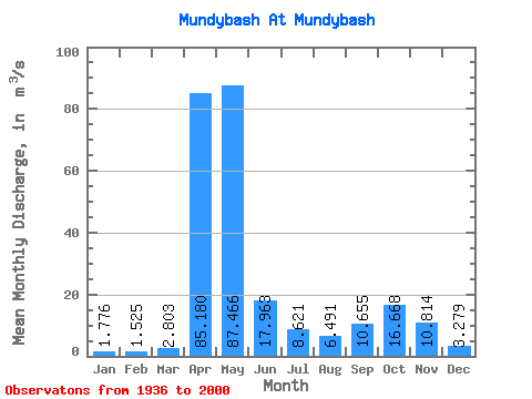
| Statistic | Jan | Feb | Mar | Apr | May | Jun | Jul | Aug | Sep | Oct | Nov | Dec | Annual |
|---|---|---|---|---|---|---|---|---|---|---|---|---|---|
| Mean | 1.78 | 1.52 | 2.80 | 85.18 | 87.47 | 17.96 | 8.62 | 6.49 | 10.65 | 16.67 | 10.81 | 3.28 | 21.10 |
| Standard Deviation | 0.96 | 0.81 | 2.74 | 30.77 | 47.88 | 14.68 | 9.48 | 5.85 | 9.61 | 11.94 | 10.88 | 2.06 | 4.73 |
| Min | 0.32 | 0.32 | 0.27 | 8.23 | 25.00 | 2.28 | 1.55 | 1.49 | 1.79 | 2.91 | 1.92 | 0.67 | 11.99 |
| Max | 5.86 | 5.60 | 18.50 | 164.00 | 233.00 | 61.50 | 54.10 | 30.30 | 46.10 | 46.00 | 64.70 | 13.20 | 35.14 |
| Coefficient of Variation | 0.54 | 0.53 | 0.98 | 0.36 | 0.55 | 0.82 | 1.10 | 0.90 | 0.90 | 0.72 | 1.01 | 0.63 | 0.22 |
 Return to R-Arctic Net Home Page