|
|
|||||||||||||||||
| Point ID: 6771 | Downloads | Plots | Site Data | Code: 10277 |
|
|
|||||||||||||||||
| Download | |
|---|---|
| Site Descriptor Information | Site Time Series Data |
| Link to all available data | |
| View: | Time Series | All |
| Units: | m3/s |
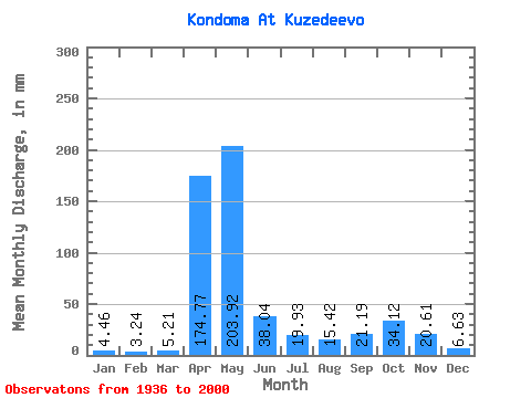
| Statistic | Jan | Feb | Mar | Apr | May | Jun | Jul | Aug | Sep | Oct | Nov | Dec | Annual |
|---|---|---|---|---|---|---|---|---|---|---|---|---|---|
| Mean | 4.46 | 3.27 | 5.21 | 174.76 | 203.89 | 38.04 | 19.92 | 15.42 | 21.19 | 34.11 | 20.61 | 6.62 | 546.31 |
| Standard Deviation | 1.59 | 0.89 | 4.08 | 68.96 | 109.69 | 28.98 | 18.61 | 13.93 | 17.95 | 25.90 | 19.22 | 3.17 | 121.24 |
| Min | 1.62 | 1.14 | 2.04 | 14.35 | 59.38 | 5.93 | 3.72 | 2.94 | 3.92 | 1.05 | 3.99 | 1.87 | 354.96 |
| Max | 8.25 | 6.62 | 32.19 | 345.60 | 518.20 | 135.82 | 92.67 | 76.03 | 84.94 | 99.10 | 103.97 | 18.72 | 849.25 |
| Coefficient of Variation | 0.36 | 0.27 | 0.78 | 0.40 | 0.54 | 0.76 | 0.93 | 0.90 | 0.85 | 0.76 | 0.93 | 0.48 | 0.22 |
 Return to R-Arctic Net Home Page