|
|
|||||||||||||||||
| Point ID: 6771 | Downloads | Plots | Site Data | Code: 10277 |
|
|
|||||||||||||||||
| Download | |
|---|---|
| Site Descriptor Information | Site Time Series Data |
| Link to all available data | |
| View: | Time Series | All |
| Units: | mm |
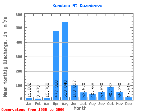
| Statistic | Jan | Feb | Mar | Apr | May | Jun | Jul | Aug | Sep | Oct | Nov | Dec | Annual |
|---|---|---|---|---|---|---|---|---|---|---|---|---|---|
| Mean | 11.80 | 9.48 | 13.77 | 477.37 | 539.05 | 103.90 | 52.67 | 40.77 | 57.89 | 90.18 | 56.29 | 17.52 | 122.56 |
| Standard Deviation | 4.21 | 2.58 | 10.78 | 188.35 | 289.99 | 79.15 | 49.19 | 36.82 | 49.03 | 68.46 | 52.50 | 8.39 | 27.20 |
| Min | 4.28 | 3.32 | 5.40 | 39.20 | 157.00 | 16.20 | 9.83 | 7.77 | 10.70 | 2.78 | 10.90 | 4.94 | 79.63 |
| Max | 21.80 | 19.20 | 85.10 | 944.00 | 1370.00 | 371.00 | 245.00 | 201.00 | 232.00 | 262.00 | 284.00 | 49.50 | 190.52 |
| Coefficient of Variation | 0.36 | 0.27 | 0.78 | 0.40 | 0.54 | 0.76 | 0.93 | 0.90 | 0.85 | 0.76 | 0.93 | 0.48 | 0.22 |
 Return to R-Arctic Net Home Page