|
|
|||||||||||||||||
| Point ID: 6770 | Downloads | Plots | Site Data | Code: 10276 |
|
|
|||||||||||||||||
| Download | |
|---|---|
| Site Descriptor Information | Site Time Series Data |
| Link to all available data | |
| View: | Time Series | All |
| Units: | m3/s |
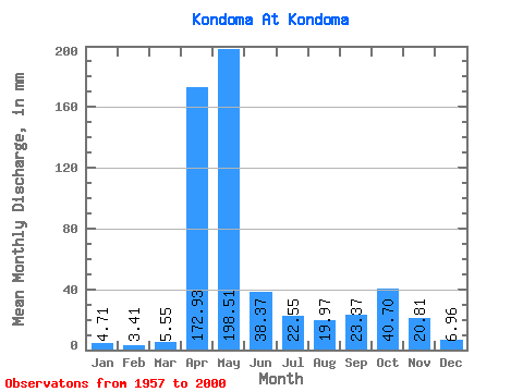
| Statistic | Jan | Feb | Mar | Apr | May | Jun | Jul | Aug | Sep | Oct | Nov | Dec | Annual |
|---|---|---|---|---|---|---|---|---|---|---|---|---|---|
| Mean | 4.71 | 3.44 | 5.55 | 172.93 | 198.48 | 38.37 | 22.54 | 19.96 | 23.37 | 40.69 | 20.81 | 6.96 | 556.47 |
| Standard Deviation | 1.96 | 1.72 | 5.56 | 67.03 | 101.26 | 29.35 | 24.91 | 20.14 | 20.79 | 31.58 | 16.45 | 2.78 | 129.92 |
| Min | 1.62 | 1.16 | 1.68 | 59.17 | 53.67 | 5.63 | 3.72 | 3.44 | 3.61 | 5.61 | 5.15 | 1.98 | 293.31 |
| Max | 12.27 | 11.18 | 35.74 | 374.86 | 489.72 | 127.02 | 138.70 | 108.83 | 73.11 | 125.90 | 78.17 | 12.48 | 859.47 |
| Coefficient of Variation | 0.42 | 0.50 | 1.00 | 0.39 | 0.51 | 0.77 | 1.10 | 1.01 | 0.89 | 0.78 | 0.79 | 0.40 | 0.23 |
 Return to R-Arctic Net Home Page