|
|
|||||||||||||||||
| Point ID: 6770 | Downloads | Plots | Site Data | Code: 10276 |
|
|
|||||||||||||||||
| Download | |
|---|---|
| Site Descriptor Information | Site Time Series Data |
| Link to all available data | |
| View: | Time Series | All |
| Units: | mm |
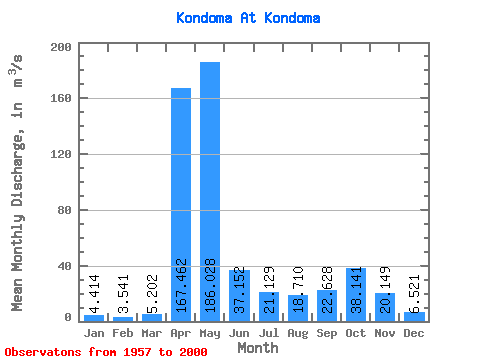
| Statistic | Jan | Feb | Mar | Apr | May | Jun | Jul | Aug | Sep | Oct | Nov | Dec | Annual |
|---|---|---|---|---|---|---|---|---|---|---|---|---|---|
| Mean | 4.41 | 3.54 | 5.20 | 167.46 | 186.03 | 37.15 | 21.13 | 18.71 | 22.63 | 38.14 | 20.15 | 6.52 | 44.26 |
| Standard Deviation | 1.84 | 1.77 | 5.21 | 64.91 | 94.91 | 28.42 | 23.35 | 18.88 | 20.13 | 29.60 | 15.93 | 2.61 | 10.33 |
| Min | 1.52 | 1.19 | 1.57 | 57.30 | 50.30 | 5.45 | 3.49 | 3.22 | 3.50 | 5.26 | 4.99 | 1.86 | 23.33 |
| Max | 11.50 | 11.50 | 33.50 | 363.00 | 459.00 | 123.00 | 130.00 | 102.00 | 70.80 | 118.00 | 75.70 | 11.70 | 68.35 |
| Coefficient of Variation | 0.42 | 0.50 | 1.00 | 0.39 | 0.51 | 0.77 | 1.10 | 1.01 | 0.89 | 0.78 | 0.79 | 0.40 | 0.23 |
 Return to R-Arctic Net Home Page