|
|
|||||||||||||||||
| Point ID: 6769 | Downloads | Plots | Site Data | Code: 10274 |
|
|
|||||||||||||||||
| Download | |
|---|---|
| Site Descriptor Information | Site Time Series Data |
| Link to all available data | |
| View: | Time Series | All |
| Units: | m3/s |
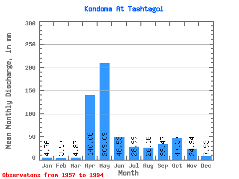
| Statistic | Jan | Feb | Mar | Apr | May | Jun | Jul | Aug | Sep | Oct | Nov | Dec | Annual |
|---|---|---|---|---|---|---|---|---|---|---|---|---|---|
| Mean | 4.76 | 3.60 | 4.87 | 140.07 | 209.06 | 48.53 | 28.99 | 26.17 | 33.47 | 47.37 | 24.34 | 7.93 | 580.16 |
| Standard Deviation | 1.60 | 1.13 | 2.48 | 53.41 | 84.06 | 32.23 | 28.77 | 23.60 | 26.24 | 30.14 | 24.61 | 3.46 | 119.43 |
| Min | 0.83 | 0.46 | 1.37 | 37.56 | 80.15 | 10.01 | 5.79 | 5.09 | 4.89 | 5.28 | 4.92 | 2.04 | 378.48 |
| Max | 9.13 | 6.35 | 16.16 | 290.60 | 473.90 | 122.52 | 145.99 | 113.86 | 95.12 | 132.63 | 136.68 | 18.07 | 823.14 |
| Coefficient of Variation | 0.34 | 0.31 | 0.51 | 0.38 | 0.40 | 0.66 | 0.99 | 0.90 | 0.78 | 0.64 | 1.01 | 0.44 | 0.21 |
 Return to R-Arctic Net Home Page