|
|
|||||||||||||||||
| Point ID: 6769 | Downloads | Plots | Site Data | Code: 10274 |
|
|
|||||||||||||||||
| Download | |
|---|---|
| Site Descriptor Information | Site Time Series Data |
| Link to all available data | |
|
|
| View: | Statistics | Time Series |
| Units: | m3/s |
| Statistic | Jan | Feb | Mar | Apr | May | Jun | Jul | Aug | Sep | Oct | Nov | Dec | Annual |
|---|---|---|---|---|---|---|---|---|---|---|---|---|---|
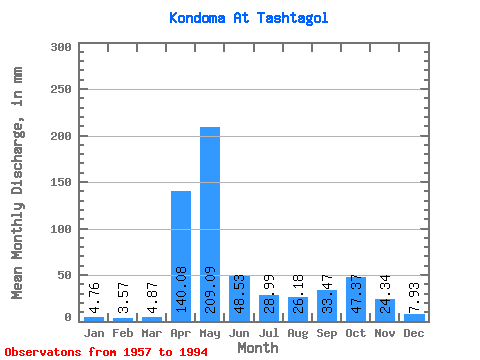
| Mean | 4.76 | 3.60 | 4.87 | 140.07 | 209.06 | 48.53 | 28.99 | 26.17 | 33.47 | 47.37 | 24.34 | 7.93 | 580.16 |
| Standard Deviation | 1.60 | 1.13 | 2.48 | 53.41 | 84.06 | 32.23 | 28.77 | 23.60 | 26.24 | 30.14 | 24.61 | 3.46 | 119.43 |
| Min | 0.83 | 0.46 | 1.37 | 37.56 | 80.15 | 10.01 | 5.79 | 5.09 | 4.89 | 5.28 | 4.92 | 2.04 | 378.48 |
| Max | 9.13 | 6.35 | 16.16 | 290.60 | 473.90 | 122.52 | 145.99 | 113.86 | 95.12 | 132.63 | 136.68 | 18.07 | 823.14 |
| Coefficient of Variation | 0.34 | 0.31 | 0.51 | 0.38 | 0.40 | 0.66 | 0.99 | 0.90 | 0.78 | 0.64 | 1.01 | 0.44 | 0.21 |
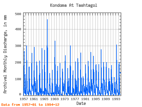
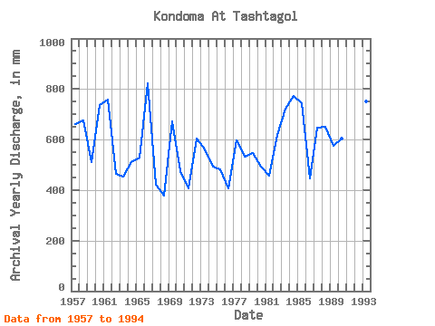
| Year | Jan | Feb | Mar | Apr | May | Jun | Jul | Aug | Sep | Oct | Nov | Dec | Annual | 1957 | 3.50 | 3.65 | 3.79 | 92.97 | 277.34 | 46.79 | 19.53 | 14.28 | 10.84 | 132.63 | 52.95 | 7.06 | 660.37 | 1958 | 4.87 | 3.83 | 4.93 | 92.35 | 309.78 | 122.52 | 54.39 | 21.44 | 11.48 | 28.18 | 17.30 | 8.02 | 675.21 | 1959 | 4.49 | 4.41 | 6.65 | 170.24 | 178.11 | 29.86 | 21.37 | 35.62 | 17.67 | 28.02 | 9.42 | 7.35 | 511.82 | 1960 | 4.17 | 5.16 | 6.96 | 135.14 | 264.62 | 56.64 | 60.11 | 28.94 | 58.80 | 44.53 | 64.65 | 8.71 | 735.96 | 1961 | 4.83 | 5.77 | 8.05 | 290.60 | 128.18 | 92.35 | 22.07 | 25.13 | 85.27 | 66.79 | 17.89 | 8.81 | 758.58 | 1962 | 6.23 | 4.06 | 8.27 | 203.79 | 161.57 | 29.09 | 8.52 | 5.09 | 4.89 | 20.10 | 7.20 | 4.04 | 462.94 | 1963 | 3.85 | 3.54 | 4.07 | 37.56 | 215.00 | 59.41 | 8.97 | 6.14 | 23.73 | 35.30 | 45.87 | 11.45 | 452.50 | 1964 | 5.28 | 2.93 | 4.87 | 73.27 | 293.24 | 29.49 | 13.71 | 17.11 | 10.01 | 27.48 | 26.50 | 11.74 | 511.19 | 1965 | 6.65 | 5.07 | 5.60 | 94.51 | 281.79 | 10.01 | 6.04 | 8.17 | 43.10 | 35.94 | 28.54 | 7.95 | 530.03 | 1966 | 5.18 | 4.46 | 4.87 | 144.68 | 473.90 | 117.90 | 10.21 | 28.31 | 5.94 | 16.48 | 9.61 | 6.96 | 823.14 | 1967 | 3.40 | 2.61 | 3.15 | 133.91 | 80.15 | 66.80 | 51.21 | 38.48 | 10.59 | 19.91 | 8.77 | 2.04 | 420.89 | 1968 | 0.83 | 0.46 | 1.37 | 153.61 | 133.90 | 13.98 | 6.49 | 14.60 | 9.17 | 16.25 | 20.32 | 7.82 | 378.48 | 1969 | 3.05 | 2.43 | 2.29 | 131.14 | 340.32 | 42.79 | 5.79 | 10.18 | 42.48 | 71.88 | 14.84 | 9.51 | 672.34 | 1970 | 6.68 | 6.35 | 4.93 | 120.98 | 183.20 | 35.09 | 11.89 | 9.29 | 22.38 | 52.16 | 14.31 | 9.26 | 474.87 | 1971 | 8.49 | 3.80 | 2.83 | 124.37 | 200.06 | 20.59 | 18.32 | 7.12 | 6.46 | 5.28 | 7.79 | 4.74 | 408.06 | 1972 | 3.12 | 3.07 | 3.44 | 161.00 | 129.76 | 29.49 | 77.92 | 27.54 | 37.86 | 73.79 | 40.33 | 18.07 | 603.59 | 1973 | 9.13 | 5.25 | 5.95 | 174.54 | 249.03 | 42.17 | 31.80 | 12.40 | 6.74 | 7.63 | 13.27 | 6.30 | 562.33 | 1974 | 2.29 | 2.12 | 2.38 | 164.08 | 81.10 | 25.52 | 14.44 | 9.89 | 70.50 | 106.23 | 7.82 | 5.66 | 492.14 | 1975 | 5.47 | 3.30 | 3.82 | 65.57 | 310.42 | 48.64 | 7.35 | 9.41 | 5.88 | 15.84 | 5.91 | 4.07 | 481.40 | 1976 | 3.56 | 3.16 | 3.53 | 95.43 | 154.25 | 16.29 | 10.59 | 43.57 | 32.94 | 38.48 | 4.92 | 3.47 | 408.02 | 1977 | 2.64 | 3.22 | 4.36 | 203.48 | 184.15 | 13.91 | 10.30 | 27.67 | 37.86 | 91.60 | 13.05 | 5.34 | 595.94 | 1978 | 5.31 | 3.48 | 5.34 | 222.88 | 184.15 | 32.32 | 11.61 | 15.68 | 8.31 | 23.00 | 15.30 | 4.77 | 532.03 | 1979 | 3.63 | 2.09 | 3.66 | 53.56 | 264.94 | 21.06 | 10.53 | 19.05 | 28.88 | 110.68 | 22.90 | 11.01 | 546.40 | 1980 | 7.16 | 1.77 | 2.86 | 113.90 | 103.37 | 102.82 | 34.67 | 14.60 | 14.90 | 29.71 | 53.87 | 14.69 | 494.92 | 1981 | 4.93 | 4.26 | 4.74 | 184.70 | 81.74 | 14.87 | 11.58 | 25.64 | 36.63 | 64.88 | 17.36 | 5.72 | 457.53 | 1982 | 4.55 | 4.00 | 5.69 | 206.56 | 147.89 | 36.02 | 21.88 | 48.66 | 15.73 | 80.15 | 36.94 | 11.83 | 618.80 | 1983 | 5.88 | 4.06 | 6.68 | 99.74 | 269.07 | 51.41 | 35.94 | 27.38 | 95.12 | 54.07 | 60.03 | 14.95 | 721.72 | 1984 | 4.93 | 2.61 | 4.45 | 79.42 | 244.90 | 74.81 | 145.99 | 113.86 | 17.73 | 64.56 | 21.27 | 5.79 | 772.88 | 1985 | 5.66 | 3.77 | 3.79 | 177.62 | 193.06 | 114.52 | 49.93 | 70.29 | 44.94 | 51.84 | 22.26 | 6.17 | 742.59 | 1986 | 5.15 | 4.14 | 5.09 | 93.28 | 194.01 | 54.18 | 8.62 | 30.79 | 24.78 | 17.30 | 7.33 | 4.71 | 447.57 | 1987 | 3.18 | 3.01 | 3.08 | 98.20 | 286.56 | 60.34 | 31.77 | 11.01 | 74.50 | 66.79 | 6.25 | 6.55 | 647.66 | 1988 | 4.39 | 2.69 | 2.35 | 200.09 | 151.39 | 35.09 | 89.37 | 94.78 | 25.06 | 33.71 | 8.47 | 6.23 | 650.94 | 1989 | 4.36 | 3.80 | 16.16 | 143.45 | 206.73 | 59.41 | 51.52 | 16.19 | 14.56 | 34.99 | 18.69 | 8.21 | 575.76 | 1990 | 4.96 | 3.48 | 4.33 | 158.84 | 168.57 | 40.63 | 28.43 | 48.34 | 84.96 | 46.44 | 8.25 | 7.60 | 603.87 | 1991 | 5.09 | 3.19 | 4.58 | 133.91 | 188.29 | 38.79 | 55.02 | 10.30 | 58.18 | 76.33 | 27.40 | 10.81 | 609.65 | 1992 | 3.98 | 3.80 | 3.72 | 110.68 | 16.78 | 16.19 | 8.68 | 79.73 | 55.34 | 18.99 | 7.47 | 1993 | 5.44 | 4.61 | 4.83 | 173.31 | 316.14 | 120.06 | 19.66 | 29.99 | 36.33 | 27.86 | 11.70 | 4.36 | 752.33 | 1994 | 4.49 | 3.45 | 7.54 | 180.09 | 202.92 | 21.80 | 7.79 | 8.87 | 56.95 | 27.80 | 136.68 | 12.12 | 671.68 |
|---|
 Return to R-Arctic Net Home Page