|
|
|||||||||||||||||
| Point ID: 6767 | Downloads | Plots | Site Data | Code: 10266 |
|
|
|||||||||||||||||
| Download | |
|---|---|
| Site Descriptor Information | Site Time Series Data |
| Link to all available data | |
| View: | Time Series | All |
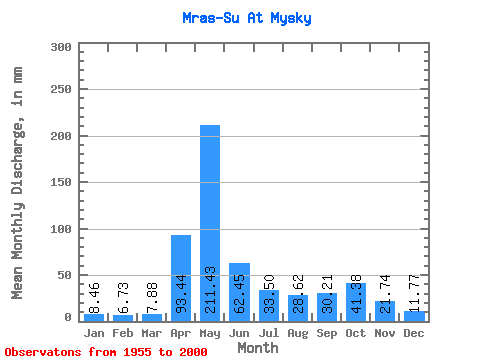
| Units: | m3/s |
| Statistic | Jan | Feb | Mar | Apr | May | Jun | Jul | Aug | Sep | Oct | Nov | Dec | Annual |
|---|---|---|---|---|---|---|---|---|---|---|---|---|---|
| Mean | 8.46 | 6.78 | 7.88 | 93.44 | 211.40 | 62.45 | 33.49 | 28.62 | 30.21 | 41.37 | 21.74 | 11.77 | 555.05 |
| Standard Deviation | 2.69 | 2.06 | 2.30 | 49.98 | 84.45 | 43.39 | 21.99 | 13.25 | 16.11 | 22.99 | 10.44 | 3.90 | 128.43 |
| Min | 2.17 | 2.41 | 4.42 | 30.67 | 99.32 | 18.19 | 10.24 | 10.30 | 10.32 | 10.18 | 6.55 | 3.53 | 293.61 |
| Max | 14.53 | 11.91 | 16.64 | 278.96 | 490.51 | 201.70 | 106.02 | 61.54 | 72.25 | 100.54 | 53.08 | 21.33 | 948.33 |
| Coefficient of Variation | 0.32 | 0.30 | 0.29 | 0.54 | 0.40 | 0.69 | 0.66 | 0.46 | 0.53 | 0.56 | 0.48 | 0.33 | 0.23 |
 Return to R-Arctic Net Home Page