|
|
|||||||||||||||||
| Point ID: 6767 | Downloads | Plots | Site Data | Code: 10266 |
|
|
|||||||||||||||||
| Download | |
|---|---|
| Site Descriptor Information | Site Time Series Data |
| Link to all available data | |
| View: | Time Series | All |
| Units: | mm |
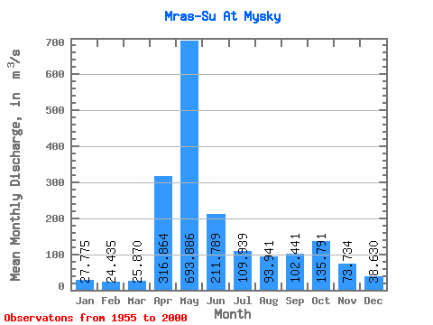
| Statistic | Jan | Feb | Mar | Apr | May | Jun | Jul | Aug | Sep | Oct | Nov | Dec | Annual |
|---|---|---|---|---|---|---|---|---|---|---|---|---|---|
| Mean | 27.77 | 24.43 | 25.87 | 316.86 | 693.89 | 211.79 | 109.94 | 93.94 | 102.44 | 135.79 | 73.73 | 38.63 | 154.59 |
| Standard Deviation | 8.84 | 7.41 | 7.55 | 169.51 | 277.20 | 147.15 | 72.17 | 43.48 | 54.63 | 75.46 | 35.40 | 12.81 | 35.77 |
| Min | 7.12 | 8.68 | 14.50 | 104.00 | 326.00 | 61.70 | 33.60 | 33.80 | 35.00 | 33.40 | 22.20 | 11.60 | 81.78 |
| Max | 47.70 | 42.90 | 54.60 | 946.00 | 1610.00 | 684.00 | 348.00 | 202.00 | 245.00 | 330.00 | 180.00 | 70.00 | 264.12 |
| Coefficient of Variation | 0.32 | 0.30 | 0.29 | 0.54 | 0.40 | 0.69 | 0.66 | 0.46 | 0.53 | 0.56 | 0.48 | 0.33 | 0.23 |
 Return to R-Arctic Net Home Page