|
|
|||||||||||||||||
| Point ID: 6766 | Downloads | Plots | Site Data | Code: 10264 |
|
|
|||||||||||||||||
| Download | |
|---|---|
| Site Descriptor Information | Site Time Series Data |
| Link to all available data | |
| View: | Time Series | All |
| Units: | m3/s |
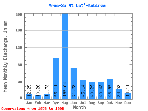
| Statistic | Jan | Feb | Mar | Apr | May | Jun | Jul | Aug | Sep | Oct | Nov | Dec | Annual |
|---|---|---|---|---|---|---|---|---|---|---|---|---|---|
| Mean | 12.24 | 10.35 | 11.73 | 95.11 | 199.01 | 71.73 | 45.13 | 40.28 | 40.42 | 46.98 | 24.02 | 14.11 | 608.95 |
| Standard Deviation | 4.31 | 3.21 | 3.85 | 43.63 | 66.37 | 33.54 | 25.70 | 21.37 | 17.64 | 21.14 | 10.35 | 7.80 | 117.28 |
| Min | 5.16 | 5.90 | 6.34 | 25.02 | 101.38 | 28.86 | 3.04 | 13.35 | 14.31 | 16.56 | 8.42 | 1.77 | 387.71 |
| Max | 24.25 | 21.40 | 24.16 | 232.22 | 415.64 | 174.98 | 127.56 | 123.34 | 85.04 | 92.08 | 55.27 | 44.77 | 881.84 |
| Coefficient of Variation | 0.35 | 0.31 | 0.33 | 0.46 | 0.33 | 0.47 | 0.57 | 0.53 | 0.44 | 0.45 | 0.43 | 0.55 | 0.19 |
 Return to R-Arctic Net Home Page