|
|
|||||||||||||||||
| Point ID: 6766 | Downloads | Plots | Site Data | Code: 10264 |
|
|
|||||||||||||||||
| Download | |
|---|---|
| Site Descriptor Information | Site Time Series Data |
| Link to all available data | |
|
|
| View: | Statistics | Time Series |
| Units: | m3/s |
| Statistic | Jan | Feb | Mar | Apr | May | Jun | Jul | Aug | Sep | Oct | Nov | Dec | Annual |
|---|---|---|---|---|---|---|---|---|---|---|---|---|---|
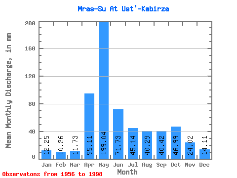
| Mean | 12.24 | 10.35 | 11.73 | 95.11 | 199.01 | 71.73 | 45.13 | 40.28 | 40.42 | 46.98 | 24.02 | 14.11 | 608.95 |
| Standard Deviation | 4.31 | 3.21 | 3.85 | 43.63 | 66.37 | 33.54 | 25.70 | 21.37 | 17.64 | 21.14 | 10.35 | 7.80 | 117.28 |
| Min | 5.16 | 5.90 | 6.34 | 25.02 | 101.38 | 28.86 | 3.04 | 13.35 | 14.31 | 16.56 | 8.42 | 1.77 | 387.71 |
| Max | 24.25 | 21.40 | 24.16 | 232.22 | 415.64 | 174.98 | 127.56 | 123.34 | 85.04 | 92.08 | 55.27 | 44.77 | 881.84 |
| Coefficient of Variation | 0.35 | 0.31 | 0.33 | 0.46 | 0.33 | 0.47 | 0.57 | 0.53 | 0.44 | 0.45 | 0.43 | 0.55 | 0.19 |
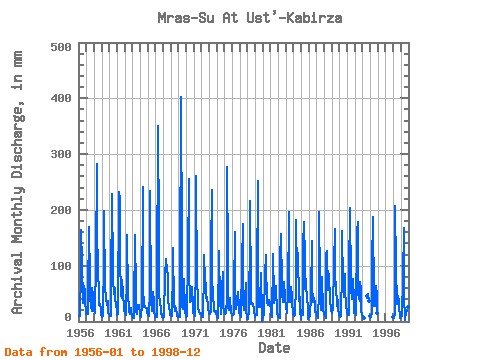
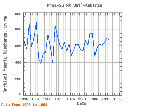
| Year | Jan | Feb | Mar | Apr | May | Jun | Jul | Aug | Sep | Oct | Nov | Dec | Annual | 1956 | 10.98 | 10.08 | 9.46 | 93.21 | 168.96 | 104.66 | 35.82 | 33.62 | 64.11 | 55.00 | 35.16 | 20.27 | 640.49 | 1957 | 14.70 | 14.39 | 14.36 | 47.26 | 174.87 | 74.33 | 45.79 | 27.12 | 19.38 | 61.25 | 45.46 | 26.86 | 563.09 | 1958 | 18.84 | 15.47 | 16.05 | 109.57 | 292.30 | 174.98 | 86.17 | 59.98 | 30.25 | 31.51 | 22.73 | 11.83 | 866.57 | 1959 | 7.49 | 8.01 | 9.71 | 113.66 | 205.28 | 58.55 | 46.55 | 42.58 | 29.44 | 38.10 | 16.03 | 13.94 | 586.61 | 1960 | 9.63 | 9.08 | 9.97 | 65.66 | 235.70 | 90.76 | 77.55 | 50.01 | 60.59 | 38.86 | 34.51 | 15.63 | 694.50 | 1961 | 12.76 | 13.24 | 19.85 | 232.22 | 227.25 | 113.66 | 47.48 | 44.01 | 74.16 | 51.95 | 24.20 | 21.12 | 881.84 | 1962 | 16.47 | 11.70 | 13.60 | 84.22 | 160.51 | 47.26 | 23.91 | 17.40 | 14.31 | 24.67 | 17.50 | 9.29 | 439.38 | 1963 | 6.72 | 5.96 | 6.34 | 25.02 | 159.67 | 53.23 | 17.74 | 14.45 | 29.35 | 28.47 | 29.60 | 13.09 | 387.71 | 1964 | 10.90 | 7.63 | 11.32 | 26.41 | 248.37 | 62.31 | 27.37 | 29.48 | 26.33 | 24.75 | 23.39 | 15.54 | 509.83 | 1965 | 11.83 | 9.54 | 9.46 | 56.66 | 241.61 | 35.98 | 20.61 | 20.02 | 52.58 | 36.92 | 20.11 | 8.96 | 521.19 | 1966 | 7.90 | 8.01 | 8.62 | 63.78 | 362.42 | 156.99 | 45.20 | 38.02 | 21.10 | 18.50 | 8.42 | 7.00 | 741.49 | 1967 | 8.35 | 8.08 | 9.55 | 81.77 | 116.58 | 103.03 | 103.91 | 76.28 | 32.95 | 32.10 | 12.18 | 12.33 | 594.68 | 1968 | 10.98 | 8.62 | 12.33 | 94.03 | 135.17 | 28.86 | 20.19 | 29.48 | 19.79 | 16.56 | 9.40 | 8.45 | 392.59 | 1969 | 10.31 | 8.16 | 9.04 | 77.68 | 415.64 | 131.64 | 28.22 | 22.89 | 43.17 | 79.41 | 20.52 | 7.41 | 848.46 | 1970 | 13.09 | 11.31 | 10.31 | 116.93 | 264.42 | 91.58 | 35.90 | 37.68 | 48.81 | 64.37 | 25.18 | 15.80 | 732.50 | 1971 | 13.43 | 11.39 | 10.81 | 110.39 | 269.49 | 64.68 | 49.51 | 25.18 | 17.82 | 16.64 | 13.49 | 14.95 | 614.52 | 1972 | 10.05 | 7.85 | 8.62 | 89.94 | 122.50 | 52.25 | 98.84 | 44.01 | 37.69 | 46.13 | 26.49 | 14.36 | 556.20 | 1973 | 17.07 | 13.39 | 18.92 | 125.92 | 243.30 | 82.58 | 42.16 | 31.59 | 18.07 | 18.25 | 19.62 | 15.63 | 644.23 | 1974 | 8.19 | 5.90 | 7.03 | 124.28 | 130.94 | 35.08 | 18.67 | 13.35 | 57.24 | 92.08 | 28.37 | 18.08 | 538.10 | 1975 | 17.66 | 13.01 | 15.29 | 41.86 | 286.38 | 107.93 | 26.86 | 21.80 | 24.53 | 43.68 | 14.55 | 11.57 | 621.33 | 1976 | 10.98 | 11.31 | 14.28 | 58.46 | 165.58 | 35.32 | 22.30 | 47.73 | 29.76 | 53.98 | 23.96 | 15.88 | 486.67 | 1977 | 11.32 | 8.39 | 11.66 | 103.84 | 180.79 | 37.04 | 21.20 | 33.79 | 42.44 | 71.30 | 23.22 | 4.66 | 547.33 | 1978 | 5.16 | 8.93 | 13.09 | 163.53 | 223.87 | 51.51 | 33.03 | 34.64 | 29.11 | 31.76 | 20.36 | 8.03 | 621.34 | 1979 | 13.52 | 13.47 | 12.42 | 80.13 | 260.20 | 48.73 | 26.19 | 26.70 | 34.59 | 90.39 | 9.65 | 1.77 | 613.61 | 1980 | 9.04 | 12.01 | 12.42 | 84.22 | 122.50 | 82.58 | 56.94 | 35.31 | 28.78 | 37.68 | 38.51 | 32.10 | 550.97 | 1981 | 20.53 | 11.55 | 7.61 | 113.66 | 125.87 | 42.19 | 34.13 | 41.99 | 57.48 | 65.47 | 16.11 | 8.29 | 543.69 | 1982 | 8.28 | 7.08 | 6.59 | 112.02 | 161.36 | 65.50 | 46.21 | 63.95 | 35.24 | 73.67 | 44.40 | 44.77 | 666.13 | 1983 | 24.25 | 16.63 | 15.54 | 50.70 | 201.91 | 59.44 | 47.48 | 35.57 | 61.65 | 45.96 | 36.63 | 14.19 | 607.39 | 1984 | 11.07 | 10.62 | 12.67 | 66.15 | 188.39 | 84.22 | 127.56 | 123.34 | 36.39 | 70.46 | 20.28 | 5.33 | 750.68 | 1985 | 20.44 | 13.55 | 12.50 | 137.37 | 184.16 | 111.20 | 60.40 | 77.97 | 60.67 | 47.73 | 21.34 | 5.42 | 751.34 | 1986 | 10.47 | 10.54 | 9.29 | 47.83 | 148.68 | 64.35 | 35.48 | 41.31 | 41.86 | 33.28 | 17.82 | 16.81 | 475.81 | 1987 | 13.43 | 8.54 | 7.01 | 54.78 | 203.60 | 69.75 | 37.09 | 21.71 | 43.09 | 82.11 | 19.21 | 17.66 | 574.53 | 1988 | 14.45 | 9.01 | 7.33 | 121.83 | 130.10 | 56.91 | 80.09 | 88.70 | 35.81 | 36.92 | 25.02 | 20.11 | 623.72 | 1989 | 16.64 | 21.40 | 24.16 | 100.57 | 171.49 | 80.54 | 64.71 | 31.59 | 27.39 | 39.03 | 21.59 | 12.00 | 609.71 | 1990 | 10.05 | 7.53 | 10.14 | 94.03 | 168.11 | 67.21 | 45.03 | 49.25 | 85.04 | 61.92 | 24.45 | 20.70 | 641.47 | 1991 | 16.73 | 10.31 | 12.50 | 85.04 | 209.51 | 69.67 | 60.15 | 42.07 | 50.29 | 79.41 | 37.45 | 15.97 | 685.62 | 1992 | 15.71 | 12.70 | 11.49 | 160.26 | 185.01 | 53.48 | 41.06 | 37.68 | 71.22 | 59.22 | 19.62 | 11.74 | 678.16 | 1993 | 9.04 | 6.53 | 6.97 | 47.39 | 44.35 | 49.06 | 38.02 | 9.55 | 1994 | 7.38 | 7.34 | 16.98 | 103.84 | 193.46 | 42.85 | 28.64 | 29.40 | 63.45 | 41.56 | 55.27 | 16.47 | 605.12 | 1997 | 7.48 | 6.32 | 14.19 | 207.69 | 101.38 | 31.23 | 33.79 | 46.38 | 35.32 | 25.43 | 12.43 | 6.56 | 528.67 | 1998 | 8.70 | 9.62 | 11.24 | 77.84 | 173.18 | 45.13 | 3.04 | 19.26 | 16.93 | 21.88 | 26.66 | 8.23 | 420.50 |
|---|
 Return to R-Arctic Net Home Page