|
|
|||||||||||||||||
| Point ID: 6765 | Downloads | Plots | Site Data | Code: 10263 |
|
|
|||||||||||||||||
| Download | |
|---|---|
| Site Descriptor Information | Site Time Series Data |
| Link to all available data | |
| View: | Time Series | All |
| Units: | m3/s |
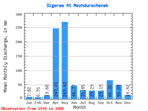
| Statistic | Jan | Feb | Mar | Apr | May | Jun | Jul | Aug | Sep | Oct | Nov | Dec | Annual |
|---|---|---|---|---|---|---|---|---|---|---|---|---|---|
| Mean | 7.82 | 6.97 | 13.68 | 247.31 | 269.38 | 46.77 | 31.84 | 29.29 | 29.20 | 66.31 | 50.09 | 14.52 | 814.17 |
| Standard Deviation | 5.98 | 4.78 | 7.66 | 127.12 | 115.69 | 27.09 | 24.57 | 17.77 | 17.43 | 40.05 | 34.90 | 10.87 | 210.47 |
| Min | 2.08 | 1.54 | 6.75 | 72.38 | 120.01 | 16.13 | 12.20 | 7.34 | 5.66 | 16.56 | 6.05 | 4.36 | 420.80 |
| Max | 24.80 | 18.98 | 38.28 | 547.20 | 512.79 | 108.48 | 98.29 | 69.73 | 80.16 | 147.79 | 108.48 | 50.88 | 1163.82 |
| Coefficient of Variation | 0.77 | 0.69 | 0.56 | 0.51 | 0.43 | 0.58 | 0.77 | 0.61 | 0.60 | 0.60 | 0.70 | 0.75 | 0.26 |
 Return to R-Arctic Net Home Page