|
|
|||||||||||||||||
| Point ID: 6765 | Downloads | Plots | Site Data | Code: 10263 |
|
|
|||||||||||||||||
| Download | |
|---|---|
| Site Descriptor Information | Site Time Series Data |
| Link to all available data | |
| View: | Time Series | All |
| Units: | mm |
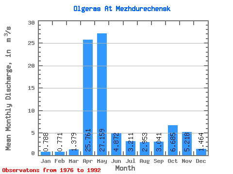
| Statistic | Jan | Feb | Mar | Apr | May | Jun | Jul | Aug | Sep | Oct | Nov | Dec | Annual |
|---|---|---|---|---|---|---|---|---|---|---|---|---|---|
| Mean | 0.79 | 0.77 | 1.38 | 25.76 | 27.16 | 4.87 | 3.21 | 2.95 | 3.04 | 6.69 | 5.22 | 1.46 | 6.96 |
| Standard Deviation | 0.60 | 0.53 | 0.77 | 13.24 | 11.66 | 2.82 | 2.48 | 1.79 | 1.82 | 4.04 | 3.64 | 1.10 | 1.80 |
| Min | 0.21 | 0.17 | 0.68 | 7.54 | 12.10 | 1.68 | 1.23 | 0.74 | 0.59 | 1.67 | 0.63 | 0.44 | 3.60 |
| Max | 2.50 | 2.10 | 3.86 | 57.00 | 51.70 | 11.30 | 9.91 | 7.03 | 8.35 | 14.90 | 11.30 | 5.13 | 9.96 |
| Coefficient of Variation | 0.77 | 0.69 | 0.56 | 0.51 | 0.43 | 0.58 | 0.77 | 0.61 | 0.60 | 0.60 | 0.70 | 0.75 | 0.26 |
 Return to R-Arctic Net Home Page