|
|
|||||||||||||||||
| Point ID: 6764 | Downloads | Plots | Site Data | Code: 10259 |
|
|
|||||||||||||||||
| Download | |
|---|---|
| Site Descriptor Information | Site Time Series Data |
| Link to all available data | |
| View: | Time Series | All |
| Units: | m3/s |
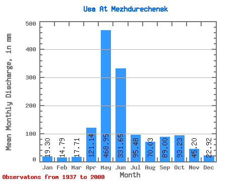
| Statistic | Jan | Feb | Mar | Apr | May | Jun | Jul | Aug | Sep | Oct | Nov | Dec | Annual |
|---|---|---|---|---|---|---|---|---|---|---|---|---|---|
| Mean | 19.30 | 14.92 | 17.71 | 121.14 | 468.88 | 331.65 | 95.47 | 70.02 | 89.00 | 93.22 | 45.20 | 22.92 | 1391.17 |
| Standard Deviation | 11.12 | 9.06 | 11.24 | 67.15 | 95.55 | 181.50 | 44.46 | 32.77 | 47.42 | 38.05 | 18.84 | 11.87 | 263.19 |
| Min | 1.73 | 1.28 | 5.57 | 16.39 | 233.12 | 56.68 | 26.62 | 16.78 | 23.11 | 42.43 | 12.57 | 5.24 | 713.21 |
| Max | 79.13 | 66.66 | 88.73 | 349.76 | 713.06 | 850.99 | 227.47 | 220.21 | 210.79 | 190.36 | 95.25 | 82.28 | 2217.44 |
| Coefficient of Variation | 0.58 | 0.61 | 0.64 | 0.55 | 0.20 | 0.55 | 0.47 | 0.47 | 0.53 | 0.41 | 0.42 | 0.52 | 0.19 |
 Return to R-Arctic Net Home Page