|
|
|||||||||||||||||
| Point ID: 6764 | Downloads | Plots | Site Data | Code: 10259 |
|
|
|||||||||||||||||
| Download | |
|---|---|
| Site Descriptor Information | Site Time Series Data |
| Link to all available data | |
| View: | Time Series | All |
| Units: | mm |
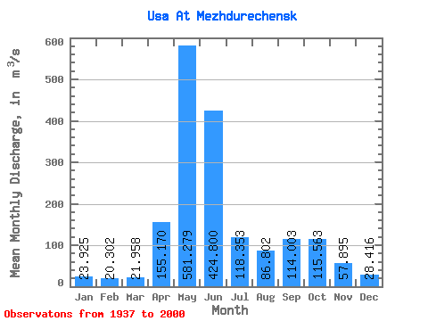
| Statistic | Jan | Feb | Mar | Apr | May | Jun | Jul | Aug | Sep | Oct | Nov | Dec | Annual |
|---|---|---|---|---|---|---|---|---|---|---|---|---|---|
| Mean | 23.93 | 20.30 | 21.96 | 155.17 | 581.28 | 424.80 | 118.35 | 86.80 | 114.00 | 115.56 | 57.90 | 28.42 | 146.35 |
| Standard Deviation | 13.78 | 12.33 | 13.94 | 86.00 | 118.45 | 232.47 | 55.12 | 40.63 | 60.73 | 47.18 | 24.14 | 14.71 | 27.69 |
| Min | 2.15 | 1.74 | 6.90 | 21.00 | 289.00 | 72.60 | 33.00 | 20.80 | 29.60 | 52.60 | 16.10 | 6.49 | 75.03 |
| Max | 98.10 | 90.70 | 110.00 | 448.00 | 884.00 | 1090.00 | 282.00 | 273.00 | 270.00 | 236.00 | 122.00 | 102.00 | 233.27 |
| Coefficient of Variation | 0.58 | 0.61 | 0.64 | 0.55 | 0.20 | 0.55 | 0.47 | 0.47 | 0.53 | 0.41 | 0.42 | 0.52 | 0.19 |
 Return to R-Arctic Net Home Page