|
|
|||||||||||||||||
| Point ID: 6760 | Downloads | Plots | Site Data | Code: 10240 |
|
|
|||||||||||||||||
| Download | |
|---|---|
| Site Descriptor Information | Site Time Series Data |
| Link to all available data | |
| View: | Time Series | All |
| Units: | m3/s |
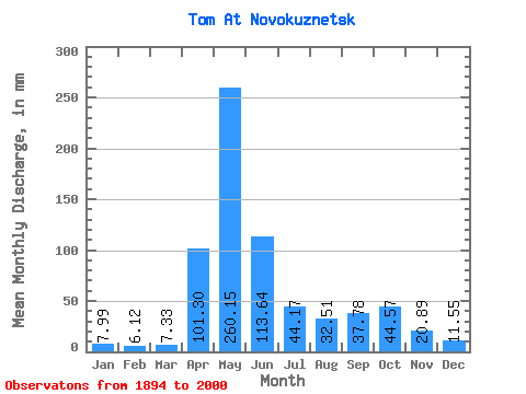
| Statistic | Jan | Feb | Mar | Apr | May | Jun | Jul | Aug | Sep | Oct | Nov | Dec | Annual |
|---|---|---|---|---|---|---|---|---|---|---|---|---|---|
| Mean | 7.99 | 6.17 | 7.33 | 101.30 | 260.11 | 113.64 | 44.16 | 32.51 | 37.78 | 44.56 | 20.89 | 11.55 | 685.17 |
| Standard Deviation | 2.54 | 1.75 | 2.63 | 52.44 | 67.34 | 53.77 | 24.56 | 16.86 | 21.50 | 22.82 | 11.78 | 4.37 | 119.31 |
| Min | 3.66 | 2.54 | 0.93 | 7.92 | 130.31 | 24.96 | 12.40 | 10.51 | 7.57 | 9.71 | 6.52 | 3.88 | 387.26 |
| Max | 18.42 | 12.36 | 18.06 | 264.42 | 452.02 | 273.99 | 141.99 | 90.76 | 116.55 | 112.33 | 60.71 | 35.14 | 1003.80 |
| Coefficient of Variation | 0.32 | 0.28 | 0.36 | 0.52 | 0.26 | 0.47 | 0.56 | 0.52 | 0.57 | 0.51 | 0.56 | 0.38 | 0.17 |
 Return to R-Arctic Net Home Page