|
|
|||||||||||||||||
| Point ID: 6760 | Downloads | Plots | Site Data | Code: 10240 |
|
|
|||||||||||||||||
| Download | |
|---|---|
| Site Descriptor Information | Site Time Series Data |
| Link to all available data | |
| View: | Time Series | All |
| Units: | mm |
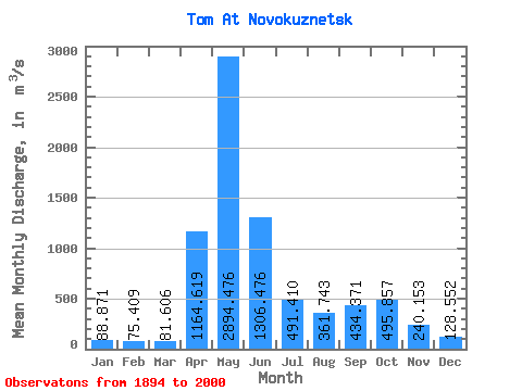
| Statistic | Jan | Feb | Mar | Apr | May | Jun | Jul | Aug | Sep | Oct | Nov | Dec | Annual |
|---|---|---|---|---|---|---|---|---|---|---|---|---|---|
| Mean | 88.87 | 75.41 | 81.61 | 1164.62 | 2894.48 | 1306.48 | 491.41 | 361.74 | 434.37 | 495.86 | 240.15 | 128.55 | 646.96 |
| Standard Deviation | 28.29 | 21.32 | 29.31 | 602.93 | 749.34 | 618.18 | 273.32 | 187.61 | 247.17 | 253.95 | 135.37 | 48.67 | 112.66 |
| Min | 40.70 | 31.00 | 10.30 | 91.00 | 1450.00 | 287.00 | 138.00 | 117.00 | 87.00 | 108.00 | 75.00 | 43.20 | 365.67 |
| Max | 205.00 | 151.00 | 201.00 | 3040.00 | 5030.00 | 3150.00 | 1580.00 | 1010.00 | 1340.00 | 1250.00 | 698.00 | 391.00 | 947.83 |
| Coefficient of Variation | 0.32 | 0.28 | 0.36 | 0.52 | 0.26 | 0.47 | 0.56 | 0.52 | 0.57 | 0.51 | 0.56 | 0.38 | 0.17 |
 Return to R-Arctic Net Home Page