|
|
|||||||||||||||||
| Point ID: 6729 | Downloads | Plots | Site Data | Code: 10176 |
|
|
|||||||||||||||||
| Download | |
|---|---|
| Site Descriptor Information | Site Time Series Data |
| Link to all available data | |
| View: | Time Series | All |
| Units: | m3/s |
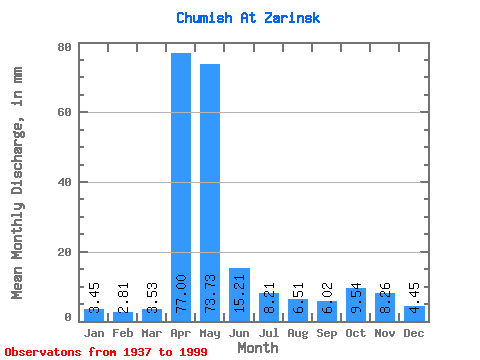
| Statistic | Jan | Feb | Mar | Apr | May | Jun | Jul | Aug | Sep | Oct | Nov | Dec | Annual |
|---|---|---|---|---|---|---|---|---|---|---|---|---|---|
| Mean | 3.45 | 2.84 | 3.53 | 77.00 | 73.72 | 15.21 | 8.21 | 6.51 | 6.02 | 9.54 | 8.26 | 4.45 | 218.24 |
| Standard Deviation | 1.19 | 0.87 | 1.75 | 32.73 | 43.13 | 11.17 | 4.44 | 3.79 | 3.53 | 6.23 | 5.58 | 2.00 | 49.36 |
| Min | 1.27 | 0.88 | 1.66 | 11.90 | 17.52 | 2.98 | 3.35 | 2.02 | 2.05 | 3.49 | 2.43 | 1.61 | 130.36 |
| Max | 7.02 | 4.51 | 14.75 | 159.92 | 212.22 | 63.09 | 28.97 | 21.05 | 24.45 | 35.54 | 33.58 | 10.75 | 340.15 |
| Coefficient of Variation | 0.34 | 0.31 | 0.50 | 0.42 | 0.58 | 0.73 | 0.54 | 0.58 | 0.59 | 0.65 | 0.68 | 0.45 | 0.23 |
 Return to R-Arctic Net Home Page