|
|
|||||||||||||||||
| Point ID: 6729 | Downloads | Plots | Site Data | Code: 10176 |
|
|
|||||||||||||||||
| Download | |
|---|---|
| Site Descriptor Information | Site Time Series Data |
| Link to all available data | |
| View: | Time Series | All |
| Units: | mm |
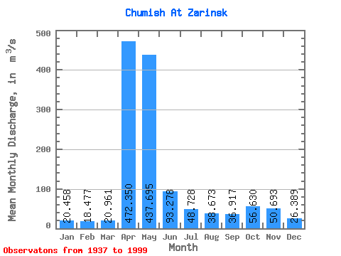
| Statistic | Jan | Feb | Mar | Apr | May | Jun | Jul | Aug | Sep | Oct | Nov | Dec | Annual |
|---|---|---|---|---|---|---|---|---|---|---|---|---|---|
| Mean | 20.46 | 18.48 | 20.96 | 472.35 | 437.69 | 93.28 | 48.73 | 38.67 | 36.92 | 56.63 | 50.69 | 26.39 | 109.95 |
| Standard Deviation | 7.04 | 5.65 | 10.40 | 200.78 | 256.10 | 68.55 | 26.37 | 22.52 | 21.63 | 36.98 | 34.20 | 11.89 | 24.87 |
| Min | 7.55 | 5.75 | 9.83 | 73.00 | 104.00 | 18.30 | 19.90 | 12.00 | 12.60 | 20.70 | 14.90 | 9.54 | 65.67 |
| Max | 41.70 | 29.40 | 87.60 | 981.00 | 1260.00 | 387.00 | 172.00 | 125.00 | 150.00 | 211.00 | 206.00 | 63.80 | 171.37 |
| Coefficient of Variation | 0.34 | 0.31 | 0.50 | 0.42 | 0.58 | 0.73 | 0.54 | 0.58 | 0.59 | 0.65 | 0.68 | 0.45 | 0.23 |
 Return to R-Arctic Net Home Page