|
|
|||||||||||||||||
| Point ID: 6728 | Downloads | Plots | Site Data | Code: 10175 |
|
|
|||||||||||||||||
| Download | |
|---|---|
| Site Descriptor Information | Site Time Series Data |
| Link to all available data | |
| View: | Time Series | All |
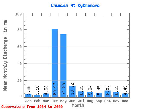
| Units: | m3/s |
| Statistic | Jan | Feb | Mar | Apr | May | Jun | Jul | Aug | Sep | Oct | Nov | Dec | Annual |
|---|---|---|---|---|---|---|---|---|---|---|---|---|---|
| Mean | 3.86 | 3.19 | 4.53 | 80.47 | 74.55 | 13.72 | 6.93 | 5.84 | 5.45 | 8.07 | 6.53 | 4.49 | 217.50 |
| Standard Deviation | 1.36 | 1.05 | 2.90 | 28.65 | 53.71 | 7.74 | 3.07 | 3.40 | 2.72 | 3.98 | 3.37 | 1.99 | 60.03 |
| Min | 1.46 | 1.07 | 2.01 | 38.64 | 15.14 | 5.07 | 2.92 | 2.48 | 2.69 | 3.21 | 2.85 | 1.65 | 117.66 |
| Max | 6.77 | 5.24 | 19.14 | 144.44 | 245.89 | 34.40 | 17.46 | 22.30 | 16.64 | 17.50 | 14.73 | 11.05 | 371.40 |
| Coefficient of Variation | 0.35 | 0.33 | 0.64 | 0.36 | 0.72 | 0.56 | 0.44 | 0.58 | 0.50 | 0.49 | 0.52 | 0.44 | 0.28 |
 Return to R-Arctic Net Home Page