|
|
|||||||||||||||||
| Point ID: 6728 | Downloads | Plots | Site Data | Code: 10175 |
|
|
|||||||||||||||||
| Download | |
|---|---|
| Site Descriptor Information | Site Time Series Data |
| Link to all available data | |
| View: | Time Series | All |
| Units: | mm |
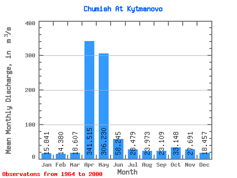
| Statistic | Jan | Feb | Mar | Apr | May | Jun | Jul | Aug | Sep | Oct | Nov | Dec | Annual |
|---|---|---|---|---|---|---|---|---|---|---|---|---|---|
| Mean | 15.84 | 14.38 | 18.61 | 341.51 | 306.23 | 58.24 | 28.48 | 23.97 | 23.11 | 33.15 | 27.69 | 18.46 | 75.81 |
| Standard Deviation | 5.59 | 4.75 | 11.91 | 121.59 | 220.63 | 32.86 | 12.60 | 13.98 | 11.54 | 16.34 | 14.32 | 8.19 | 20.93 |
| Min | 6.00 | 4.81 | 8.25 | 164.00 | 62.20 | 21.50 | 12.00 | 10.20 | 11.40 | 13.20 | 12.10 | 6.78 | 41.01 |
| Max | 27.80 | 23.60 | 78.60 | 613.00 | 1010.00 | 146.00 | 71.70 | 91.60 | 70.60 | 71.90 | 62.50 | 45.40 | 129.45 |
| Coefficient of Variation | 0.35 | 0.33 | 0.64 | 0.36 | 0.72 | 0.56 | 0.44 | 0.58 | 0.50 | 0.49 | 0.52 | 0.44 | 0.28 |
 Return to R-Arctic Net Home Page